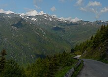
Zillertal High Road
The Zillertaler Höhenstraße is a mountain road in the Tux Pre-Alps , which is located in the southern part of the Zillertal . It consists of an apex stretch high above the valley floor, as well as five different access roads that lead up from the Zillertalstrasse to this section of the route. While the average 8 km long access roads can be used toll-free, a toll must be paid for the almost 20 km long central route when driving with motor vehicles .
Characteristic
The apex of the Zillertaler Höhenstraße leads in a strongly winding course along the western slope of the Zillertaler Taltroge. This section of the route is mostly located above the tree line at altitudes of around 1700 to 2100 meters, in an area that extends west of the municipality of Zell am Ziller . This section is laid out as a panoramic road, and in its southern area the Höhenstraße reaches its highest point with the Arbisjochkopf at 2133 m. The apex section is predominantly a single-lane carriageway on which evasive lanes were repeatedly created at certain intervals - especially after narrow passages. The level of difficulty according to the Denzel Alpine Road scale is around 2 to 3 in this area.
The northernmost access road to the apex has its starting point at an altitude of 573 m in Ried in the Zillertal . This road leads to the north toll station near the Riedbach at 1400 m altitude, which forms the northern end point of the apex route. A second possibility to drive to this toll station is to use the driveway starting near Kaltenbach at 558 m.
The southern end of the apex route is connected to the Zillertalstraße via an access road, which has its starting point in Ramsau . From there it goes from a height of 604 m mainly through the valley of the Sidanbach to the toll station south, which is at 1730 m.
There are also access roads from Aschau and Zellberg , with which the apex of the Zillertaler Höhenstraße can be reached. However, these access roads cannot be used to approach the endpoints of the apex, but these paths reach the Höhenstraße (at different points) in the middle of its course.
History and operator
Regardless of its current use, the construction of the Zillertaler Höhenstraße does not go back to tourist development purposes. With the construction of this road, it was primarily intended to enable the installation of mining safety devices above the tree line. These had become necessary to improve protection against avalanches and mudslides.
The operator is the Weggemeinschaft Zillertaler Höhenstraße , which also includes 5 member communities. These built the streets in the early 1960s. In 1978 the connection from Zell to the Zellberg was built, and since then tolls have been levied due to increasing tourist use.
literature
- Eduard Denzel, Harald Denzel: Great Alpine Road Guide. 23rd edition. Denzel-Verlag, Innsbruck 2007, ISBN 978-3-85047-766-6 .
- Harald Denzel: Motorcycle tours in the Eastern Alps. Denzel-Verlag, Innsbruck 2003, ISBN 3-85047-761-4 .
- Rudolf Geser: Alpine passes and mountain roads by bike. The 75 most beautiful tour suggestions. BLV Verlagsgesellschaft mbH, Munich 1992, ISBN 3-405-13452-8 .
- Eduard Denzel: Denzel combination guide car + hiking shoe. Volume 4: North Tyrol. Harald Denzel KG, Innsbruck 1989, ISBN 3-85047-739-8 .
- Walter Klier : Zillertal, with Gerlos and Tux valleys. Bergverlag Rother GmbH, Munich 2008, ISBN 978-3-7633-4175-7 .
- Michael Reimer, Wolfgang Taschner: Hiking in the Zillertal. DuMont Buchverlag, Cologne 2001, ISBN 3-7701-5317-0 .
- Freytag & Berndt-Verlag Vienna, hiking map 1: 50,000, sheet WK 151, Zillertal, Tux Alps, Jenbach-Schwaz. ISBN 978-3-85084-751-3 .
Web links
Tour reports:
- The Zillertaler Höhenstraße on AlpenpassBiker.de
- Experience report of the Zillertaler Höhenstraße bike tour
Individual evidence
Coordinates: 47 ° 14 ' N , 11 ° 49' E

