Zirakpur
| Zirakpur | ||
|---|---|---|
|
|
||
| State : |
|
|
| State : | Punjab | |
| District : | Sahibzada Ajit Singh Nagar | |
| Location : | 30 ° 39 ′ N , 76 ° 49 ′ E | |
| Height : | 350 m | |
| Residents : | 95,553 (2011) | |
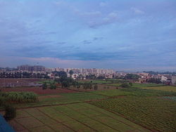
| View of Zirakpur | ||
Zirakpur is a city in the Indian state of Punjab . It forms a suburb of Chandigarh , which is one of the wealthiest cities in India. That is why Zirakpur itself is also experiencing rapid population growth.
The city is part of the Sahibzada Ajit Singh Nagar district . Zirakpur has the status of a Municipal Council. The city is divided into 15 wards (constituencies).
Demographics
The city's population is 95,553 according to the 2011 census. Zirakpur has a gender ratio of 892 women per 1000 men and thus a male surplus typical for India. The literacy rate was 88.3% in 2011. Almost 73% of the population are Hindus , approx. 22% are Sikhs , approx. 3% are Muslims and approx. 1% belong to another or no religion. Children under 6 years of age are 12.6% of the population.
Infrastructure
Zirakpur is well connected to Chandigarh, Panchkula and other neighboring areas by air-conditioned and non-air-conditioned local buses . The interstate buses from Chandigarh to Delhi , Patiala , Rajpura , Bathinda and most of the northern cities of Haryana pass through Zirakpur. Zirakpur is on the Ambala-Chandigarh and Patiala-Shimla Motorways. The nearest train station is in Chandigarh, around 8 km from Zirakpur.
Web links
Individual evidence
- ↑ www.census2011.co.in
- ↑ Zirakpur Municipal Council City Population Census 2011-2019 | Punjab. Retrieved November 3, 2019 .

