Zoitzberg
| Zoitzberg | ||
|---|---|---|
|
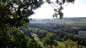
View from Zoitzberg into the Elstertal |
||
| height | 284.6 m above sea level NN | |
| location | Thuringia , Germany | |
| Coordinates | 50 ° 50 '4 " N , 12 ° 4' 51" E | |
|
|
||
| rock | Greywacke and slate | |
The Zoitzberg is the local mountain of Liebschwitz and Taubenpreskel and a destination in the south of the city of Gera . It has a height of 284 m above sea level, i. H. 84 meters above the valley floor.
location
The mountain is located in the south of the city of Gera on the corridors of the Liebschwitz and Taubenpreskel districts. As a striking mountain spur at the end of the plateaus east of the White Elster , it forms a valley gate to the Wünschendorfer Basin with the Heeresberg opposite .
Word origin
The name "Zoitzberg" is clearly of Slavic origin. "Zoitz" is very likely derived from the Slavic word for jay "sojacy". An interpretation of “Häherberg” is therefore obvious.
geology
The mountain is a geological boundary between geologically younger sedimentary rocks ( Triassic ) in the Wünschendorfer Basin and rocks of the geological era. Together with the Schieferberg, Mühlberg and Hayn, it forms a rock barrier that is clearly visible when coming from the direction of Meilitz . Its rock formations belong to a geological fault line . The rocks are from the time of the Lower Carboniferous (Kulm): reddish-brown greywacke and dark slate . A geological outcrop with a U-shaped fault is visible on the west wall facing the Elstertal .
Mining
The first mining attempts at the foot of the Zoitzberg were made in 1779. At the site of the quarry on the Salzstrasse, which is still visible today, geologists discovered what was supposed to be a coal leak. A first, approx. 160 m deep tunnel was created. After these first attempts at digging were stopped, there was a second mining operation in 1789/1790. It was found that it is "poorly combustible coal", namely Antraxolite . The break was abandoned. Later, building materials for building houses, walls and paths were transported away from there several times.
Archaeological excavations
In the years between 1923 and 1938 there were more and more prehistoric finds in the Liebschwitz area, so in 1923 Bruno Brause discovered a temporary human habitation from the Younger Paleolithic on the northern slope of the Zoitzberg ridge . Around 19,000 years ago, people lived here in a so-called open air station . The resting place served as a camp and starting point for the hunt, which is proven by numerous flint finds. Since 1923 there have been further archaeological excavations there. A second site is at the foot of the mountain on a high terrace at the entrance to the Iltistal. The flint stones found there (first excavations when the house was built in 1936) can be dated from 15,000 to 12,000 years ago, i.e. at the end of the last ice age. A third important site is located directly on the top of the mountain. Approx. 80 m from the lookout point, parts of a former ring wall can still be seen today in the form of a clear elevation. It is a Bronze Age defense system (1800–700 BC), which was first explored in 1930 with trenching.
flora
Most of the mountain is covered with oak forest. The north flank is used for agriculture. The coniferous forest on the northern slope had to be felled in July 2005 due to pest infestation. The oak forest was felled several times at longer intervals, especially in the 20th century, so that the trees form large, bulbous trunk bases. The bark of the oaks was used for the production of tannins in the loader works. Various types of mushrooms and some typical plants grow in the oak forest, such as B. the grape grass lily .
fauna
Fire salamanders , grass snakes and sand lizards can be found at the foot of the mountain . Hares , rabbits , foxes and deer are part of the mountain fauna, as are red kites and falcons .
tourism
Various regional hiking trails and the Thuringia hiking trail lead across the mountain. A first refuge was built in July 1955 by young people from Liebschwitz. After being damaged several times, citizens of the district built a massive refuge in 1987 as part of the “Mach-Mit-Movement”, which is still preserved today. The previous buildings were made of wood. In the 1970s the barrel hut was built on the way from Bergsporn to Alt-Taubenpreskel.
Say
The best known is the legend of the Otternkönig, but also the legends of the "Liebschwitzer Satchel Man" and the "Pumphut" collected by Robert Eisel are connected with the mountain and its history.
68 bombs were dropped on the north side of the Zoitzberg during World War II. Some of the detonation funnels are still visible today.


