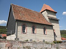
Zwabitz
|
Zwabitz
Bibra parish
Coordinates: 50 ° 48 ′ 48 ″ N , 11 ° 32 ′ 54 ″ E
|
|
|---|---|
| Height : | 269 m above sea level NN |
| Incorporation : | July 1, 1978 |
| Postal code : | 07768 |
| Area code : | 036424 |
|
View over the village green of Zwabitz
|
|
Zwabitz is a district of Bibra in the Saale-Holzland district in Thuringia .
geography
Zwabitz is located to the west of Kahla on a level-like, elevated, south-sloping slope of the Saale-Ilm limestone slab. The village is connected to the federal highway 88 via district roads . The wooded Hornberg borders the Feldmark to the north.
history
The beautifully situated village was first mentioned in a document in 1221.
The agricultural village was also subject to the development of agriculture in the Soviet Zone and GDR. After the reunification of the two German states, the farmers joined the agricultural cooperative Reinstädter Grund eG.
church
Individual evidence
- ^ Wolfgang Kahl : First mention of Thuringian towns and villages. A manual. 5th, improved and considerably enlarged edition. Rockstuhl, Bad Langensalza 2010, ISBN 978-3-86777-202-0 , p. 327.
Web links
Commons : Zwabitz - Collection of images, videos and audio files

