
Tjerkwerd: Difference between revisions
No edit summary |
KittenKlub (talk | contribs) corr |
||
| (10 intermediate revisions by 6 users not shown) | |||
| Line 1: | Line 1: | ||
{{Expand West Frisian|date=December 2008|Tsjerkwert}} |
|||
{{Infobox settlement |
{{Infobox settlement |
||
| name = Tjerkwerd |
|||
|official_name = Tsjerkwerd |
|||
| |
| native_name = Tsjerkwert |
||
| native_name_lang = <!-- ISO 639-2 code e.g. "fr" for French. If more than one, use {{lang}} instead --> |
|||
|image_map = Map NL Wûnseradiel Tsjerkwert.png |
|||
| settlement_type = Village |
|||
|mapsize = 280px |
|||
| image_skyline = Tjerkwerd Tsjerkwert.jpg |
|||
|subdivision_type = Country |
|||
| image_alt = |
|||
|subdivision_name = {{flagicon|Netherlands}} [[Netherlands]] |
|||
| image_caption = |
|||
|subdivision_type1 = Province |
|||
| image_flag = Tsjerkwerd vlag.svg |
|||
|subdivision_name1 = {{flagicon|Friesland}} [[Friesland]] |
|||
| flag_alt = |
|||
|settlement_type = Village |
|||
| image_seal = |
|||
|population_total = c. 460 |
|||
| seal_alt = |
|||
| image_shield = Tsjerkwert wapen.svg |
|||
| shield_alt = |
|||
| etymology = |
|||
| nickname = |
|||
| motto = |
|||
| image_map = Map NL Wûnseradiel Tsjerkwert.png |
|||
| map_alt = |
|||
| map_caption = Location in the former Wûnseradiel municipality |
|||
| pushpin_map = Netherlands Friesland#Netherlands<!-- the name of a location map as per http://en.wikipedia.org/wiki/Template:Location_map --> |
|||
| pushpin_label_position = right |
|||
| pushpin_mapsize = 250 |
|||
| pushpin_map_caption = Location in the Netherlands |
|||
| coordinates = {{coord|53|2|31|N|5|30|4|E|display=title|region:NL_type:city_source:nlwiki}} |
|||
| coor_pinpoint = |
|||
| coordinates_footnotes = |
|||
| subdivision_type = [[List of sovereign states|Country]] |
|||
| subdivision_name = {{flagicon|Netherlands}} [[Netherlands]] |
|||
| subdivision_type1 = [[Provinces of the Netherlands|Province]] |
|||
| subdivision_name1 = {{flagicon|Friesland}} [[Friesland]] |
|||
| subdivision_type2 = [[List of municipalities of the Netherlands|Municipality]] |
|||
| subdivision_name2 = {{flagicon|Súdwest-Fryslân}} [[Súdwest-Fryslân]] |
|||
| subdivision_type3 = |
|||
| subdivision_name3 = |
|||
| established_title = |
|||
| established_date = |
|||
| founder = |
|||
| seat_type = |
|||
| seat = |
|||
| government_footnotes = |
|||
| leader_party = |
|||
| leader_title = |
|||
| leader_name = |
|||
| unit_pref = Metric |
|||
<!-- ALL fields with measurements have automatic unit conversion --> |
|||
<!-- for references: use <ref> tags --> |
|||
| area_footnotes = <ref name="stat"/> |
|||
| area_total_km2 = 12.05 |
|||
| elevation_footnotes = <ref name="AHN">{{cite web |url = http://www.ahn.nl/postcodetool |title = Postcodetool for 8765LH |language = nl |work = Actueel Hoogtebestand Nederland |publisher = Het Waterschapshuis |access-date = 6 April 2022 }}</ref> |
|||
| elevation_m = 0.0 |
|||
| population_as_of = 2021 |
|||
| population_footnotes = <ref name="stat">{{cite web |url=https://www.cbs.nl/-/media/_excel/2021/48/kwb-2021.xls |title=Kerncijfers wijken en buurten 2021 |website=Central Bureau of Statistics |access-date=6 April 2022|quote=two entries}}</ref> |
|||
| population_total = 450 |
|||
| population_density_km2 = auto |
|||
| population_note = |
|||
| population_demonym = |
|||
| timezone1 = |
|||
| utc_offset1 = |
|||
| timezone1_DST = |
|||
| utc_offset1_DST = |
|||
| timezone = [[Central European Time|CET]] |
|||
| utc_offset = +1 |
|||
| timezone_DST = [[Central European Summer Time|CEST]] |
|||
| utc_offset_DST = +2 |
|||
| postal_code_type = [[List of postal codes in the Netherlands|Postal code]] |
|||
| postal_code = 8765<ref name="stat"/> |
|||
| area_code_type = [[Telephone numbers in the Netherlands|Dialing code]] |
|||
| area_code = 0515 |
|||
| iso_code = |
|||
| footnotes = |
|||
}} |
}} |
||
''' Tjerkwerd ''' ({{lang-fry|Tsjerkwert}}) is a village in [[Súdwest-Fryslân]] municipality in the province [[Friesland]] of the [[Netherlands]]. It had a population of 455 in January 2017.<ref>[http://statline.cbs.nl/Statweb/publication/?DM=SLNL&PA=83765NED&D1=0-1,3-4,8,11,14,28,31-32,99-104&D2=13314-13470&HDR=T&STB=G1&VW=T Kerncijfers wijken en buurten 2017] - CBS Statline</ref> |
|||
There is a [[windmill]] in the village, [[De Babuurstermolen, Tjerkwerd|De Babuurstermolen]]. |
|||
==History== |
|||
The village was first mentioned in the 13th century as Kercwere, and means "''terp'' with church".<ref>{{cite web|url=https://etymologiebank.nl/trefwoord/tjerkwerd |title=Tjerkwerd - (geografische naam) |website=Etymologiebank |access-date=6 April 2022 |language=nl}}</ref> Tjerkwerd is a ''[[terp]]'' (artificial living hill) village with a radial structure.<ref name="monument">{{cite web|url=https://www.dbnl.org/tekst/sten009monu06_01/sten009monu06_01_0178.php |title=Tjerkwerd |author=Ronald Stenvert & Sabine Broekhoven |year=2000 |publisher=Waanders |location=Zwolle |isbn=90 400 9476 4 |language=nl |access-date=5 April 2022}}</ref> |
|||
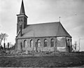
The Dutch Reformed church was probably built in the 14th century. In 1888, it was extended and a new tower was constructed.<ref name="monument"/> The Walta State was a ''[[stins]]'' built at the end of the 15th century, and used to be owned by the [[Cammingha]] family. The estate was demolished around 1800.<ref name="wonder"/><ref>{{cite web|url=http://www.stinseninfriesland.nl/WaltaStateTjerkwerd.htm |title=Walta State te Tjerkwerd |website=Stinsen in Friesland |access-date=6 April 2022 |language=nl}}</ref> Watse van Cammingha died in 1688. Rixt van Donia, his widow, became the richest woman in Friesland at the time, and is buried in a large marble monument.<ref name="wonder">{{cite web|url=https://www.frieslandwonderland.nl/friesland/plaats/tjerkwerd |title=Tjerkwerd |website=Friesland wonderland |access-date=7 April 2022 |language=nl}}</ref> |
|||
The polder mill [[De Babuurstermolen, Tjerkwerd|De Babuurstermolen]] was built in 1882. It was in active service draining the excess water from the ''[[polder]]'' until 1990 when it was replaced by a pumping station. In 2006, it was re-designated as backup.<ref>{{cite web|url=https://www.molendatabase.nl/nederland/molen.php?nummer=137 |title=Beabuorster Mole |website=Molendatabase |access-date=6 April 2022 |language=nl}}</ref> |
|||
Tjerkwerd was home to 249 people in 1840.<ref name="plaats">{{cite web|url=https://www.plaatsengids.nl/tjerkwerd |title=Tjerkwerd |website=Plaatsengids |access-date=6 April 2022 |language=nl}}</ref> From 1850 onwards, a linear settlement developed along the Workumer Trekvaart.<ref name="monument" /> Before 2011, the village was part of the [[Wûnseradiel]] municipality. In 2015, the road to Tjerkwerd received an award for worst road of Friesland. The road was fixed by the municipality between 2016 and 2017.<ref name="plaats"/> |
|||
==Gallery== |
|||
<gallery> |
|||
File:Brug bij Tjerkwerd.jpg|The bridge in Tjerkwerd |
|||
File:Tjerkwerd Workumertrekvaart 2009.jpg|Canal view |
|||
File:20190821 zicht op de Babuurstermolen vanuit het noordwesten.jpg|Babuurstermolen |
|||
File:Exterieur naar het noorden - Tjerkwerd - 20209690 - RCE.jpg|Church of Tjerkwerd |
|||
</gallery> |
|||
==References== |
|||
{{Reflist}} |
|||
==External links== |
|||
{{commonscat-inline}} |
|||
{{Dutch municipality Súdwest-Fryslân}} |
{{Dutch municipality Súdwest-Fryslân}} |
||
{{Authority control}} |
|||
{{coord|53|2|31|N|5|30|4|E|display=title|region:NL_type:city_source:nlwiki}} |
|||
[[Category:Súdwest-Fryslân]] |
[[Category:Súdwest-Fryslân]] |
||
[[Category:Populated places in Friesland]] |
[[Category:Populated places in Friesland]] |
||
{{Friesland-geo-stub}} |
|||
Latest revision as of 06:56, 7 April 2022
Tjerkwerd
Tsjerkwert | |
|---|---|
Village | |
 | |
 Flag  Coat of arms | |
 Location in the former Wûnseradiel municipality | |
 Tjerkwerd Location in the Netherlands  Tjerkwerd Tjerkwerd (Netherlands) | |
| Coordinates: 53°2′31″N 5°30′4″E / 53.04194°N 5.50111°E | |
| Country | |
| Province | |
| Municipality | |
| Area | |
| • Total | 12.05 km2 (4.65 sq mi) |
| Elevation | 0.0 m (0.0 ft) |
| Population (2021)[1] | |
| • Total | 450 |
| • Density | 37/km2 (97/sq mi) |
| Postal code | 8765[1] |
| Dialing code | 0515 |
Tjerkwerd (West Frisian: Tsjerkwert) is a village in Súdwest-Fryslân municipality in the province Friesland of the Netherlands. It had a population of 455 in January 2017.[3]
There is a windmill in the village, De Babuurstermolen.
History[edit]
The village was first mentioned in the 13th century as Kercwere, and means "terp with church".[4] Tjerkwerd is a terp (artificial living hill) village with a radial structure.[5]
The Dutch Reformed church was probably built in the 14th century. In 1888, it was extended and a new tower was constructed.[5] The Walta State was a stins built at the end of the 15th century, and used to be owned by the Cammingha family. The estate was demolished around 1800.[6][7] Watse van Cammingha died in 1688. Rixt van Donia, his widow, became the richest woman in Friesland at the time, and is buried in a large marble monument.[6]
The polder mill De Babuurstermolen was built in 1882. It was in active service draining the excess water from the polder until 1990 when it was replaced by a pumping station. In 2006, it was re-designated as backup.[8]
Tjerkwerd was home to 249 people in 1840.[9] From 1850 onwards, a linear settlement developed along the Workumer Trekvaart.[5] Before 2011, the village was part of the Wûnseradiel municipality. In 2015, the road to Tjerkwerd received an award for worst road of Friesland. The road was fixed by the municipality between 2016 and 2017.[9]
Gallery[edit]
-
 The bridge in Tjerkwerd
 -
 Canal view
 -
 Babuurstermolen
 -
 Church of Tjerkwerd


References[edit]
- ^ a b c "Kerncijfers wijken en buurten 2021". Central Bureau of Statistics. Retrieved 6 April 2022.
two entries
- ^ "Postcodetool for 8765LH". Actueel Hoogtebestand Nederland (in Dutch). Het Waterschapshuis. Retrieved 6 April 2022.
- ^ Kerncijfers wijken en buurten 2017 - CBS Statline
- ^ "Tjerkwerd - (geografische naam)". Etymologiebank (in Dutch). Retrieved 6 April 2022.
- ^ a b c Ronald Stenvert & Sabine Broekhoven (2000). "Tjerkwerd" (in Dutch). Zwolle: Waanders. ISBN 90 400 9476 4. Retrieved 5 April 2022.
- ^ a b "Tjerkwerd". Friesland wonderland (in Dutch). Retrieved 7 April 2022.
- ^ "Walta State te Tjerkwerd". Stinsen in Friesland (in Dutch). Retrieved 6 April 2022.
- ^ "Beabuorster Mole". Molendatabase (in Dutch). Retrieved 6 April 2022.
- ^ a b "Tjerkwerd". Plaatsengids (in Dutch). Retrieved 6 April 2022.
External links[edit]
![]() Media related to Tjerkwerd at Wikimedia Commons
Media related to Tjerkwerd at Wikimedia Commons