Woudsend
 flag |
 coat of arms |
| province |
|
| local community |
|
|
Area - land - water |
31.38 km 2 22.09 km 2 9.29 km 2 |
| Residents | 1,660 (Jan 1, 2017) |
| Coordinates | 52 ° 57 ' N , 5 ° 38' E |
| Important traffic route |
|
| prefix | 0514 |
| Postcodes | 8529, 8551, 8554 |
| Website | Homepage of Woudsend |
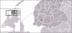
Woudsend ( West Frisian Wâldsein ) is a place in the municipality of Súdwest-Fryslân , formerly Wymbritseradiel in the Dutch province of Friesland . The population is 1660 (as of January 1, 2017).
location
The place is at the intersection of several waterways. The Ie forms the connection to the nearby Sleatemer Mar in the south, the Wâldseinder Rakken connects the place with the west lying Hegemer Mar and the place Heeg . In the north Woudsend is connected to the towns of IJlst and Sneek by the Nauwe Wimerts , to the east the Wellesleat forms a connection to the Koevorder Meer and the Prinses-Margriet Canal .
Woudsend is close to the N354, the main road that connects Sneek and Lemmer.
history
Originally, Woudsend is an agricultural settlement in the area of the municipality of Ypecolsga. The independent development as a village goes back to around the year 1000. Woudsend was first mentioned in a document in 1337. In that year a Carmelite monastery was founded here. The town owes its development as a trade and shipping center to its favorable location on central waterways. The Woudsender Ee was on the route from the Zuiderzee ( IJsselmeer ) to Sneek and IJlst and Leeuwarden . The town had its heyday in the 18th and 19th centuries. In 1749 there were 734 inhabitants, more than a third of whom were employed in fishing and shipping. Around 1750 about 25 to 30 seagoing ships had Woudsend as their home port . In 1825, 17 people died in a flood, in the following over 100 people in the community died in a flood disaster (a total of 4000 in Friesland). In 1840 the place had 1200 inhabitants and in 1890 1400 people lived here. Today Woudsend is a location for water sports. Many boats pass here on the way from Lemmer and Sloten to Hegemer Mar and Sneek.
Attractions
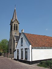
- Carmelite Church
- St. Michael's Church
- The formerly Reformed Church; meanwhile converted into a residential building
- The former Mennonite Church (Doopgezinde Kerk); has housed a restaurant for more than 30 years; only once a year on the 1st of Advent a service
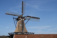
- The De Jager wood sawmill
- The Het Lam flour mill
Events
- Every two years the Friese Sleepbootdagen takes place in Woudsend , an event with historical tugs.
Web links
- Place website (Dutch)
- Woudsend Coat of Arms (Dutch)
- Tourist information website (Dutch)
- Woudsends Skûtsje for the well-known Skûtsjesielen (cargo ship sailing) (Dutch)
Individual evidence
- ↑ a b Kerncijfers wijken en buurten 2017 Centraal Bureau voor de Statistiek , accessed on June 19, 2018 (Dutch)
- ^ History of Woudsend (Tourist Information VVV, Dutch)
- ↑ Info from the community ( Memento of the original from August 17, 2016 in the Internet Archive ) Info: The archive link was inserted automatically and has not yet been checked. Please check the original and archive link according to the instructions and then remove this notice. (Dutch)
- ↑ Chronicle of Woudsend ( Memento of the original from February 22, 2014 in the Internet Archive ) Info: The archive link was automatically inserted and not yet checked. Please check the original and archive link according to the instructions and then remove this notice. (Dutch)


