
Beachy Head: Difference between revisions
→In Popular Culture: rm trivia |
bought in 1929 |
||
| Line 7: | Line 7: | ||
'''Beachy Head''' is a [[chalk]] [[headlands and bays|headland]] on the south coast of [[England]], close to the town of [[Eastbourne, East Sussex|Eastbourne]] in the county of [[East Sussex]]. The [[cliff]] there is the highest chalk sea cliff in Britain, rising to 162 [[metre|m]] (530 [[Foot (unit of length)|ft]]) above sea level. The peak allows views of the south east coast from [[Dungeness]] to the east, to [[Selsey Bill]] in the west. Its height has also made it a notorious [[suicide]] spot. |
'''Beachy Head''' is a [[chalk]] [[headlands and bays|headland]] on the south coast of [[England]], close to the town of [[Eastbourne, East Sussex|Eastbourne]] in the county of [[East Sussex]]. The [[cliff]] there is the highest chalk sea cliff in Britain, rising to 162 [[metre|m]] (530 [[Foot (unit of length)|ft]]) above sea level. The peak allows views of the south east coast from [[Dungeness]] to the east, to [[Selsey Bill]] in the west. Its height has also made it a notorious [[suicide]] spot. |
||
==Geology== |
|||
The chalk was formed in the [[Cretaceous]] period when the area was under the sea, 65 million years ago and earlier. During the [[Cenozoic]] Era the chalk was [[Geology of England#Cenozoic Era|uplifted]], and was later eroded to form the dramatic cliffs of the Sussex coast. |
The chalk was formed in the [[Cretaceous]] period when the area was under the sea, 65 million years ago and earlier. During the [[Cenozoic]] Era the chalk was [[Geology of England#Cenozoic Era|uplifted]], and was later eroded to form the dramatic cliffs of the Sussex coast. |
||
Some of the cliffs were lost in 2001 when, after a winter of heavy rains, a chalk pinnacle known as the Devil's Chimney collapsed into the sea. |
Some of the cliffs were lost in 2001 when, after a winter of heavy rains, a chalk pinnacle known as the Devil's Chimney collapsed into the sea. |
||
==History== |
|||
The name Beachy Head appears as 'Beauchef' in [[1274]], and was Beaucheif in [[1317]], becoming consistently Beachy Head by 1724, and has nothing to do with beach. Instead it is a corruption of the original French words meaning Beautiful Headland.<REF NAME=SURTEES>{{Harvard reference|Surname=Surtees|Given=Dr John|Year=1997|Title=Beachy Head|Place=Seaford|Publisher=SB Publications|ISBN=1 85770 118 6|}}</REF> |
The name Beachy Head appears as 'Beauchef' in [[1274]], and was Beaucheif in [[1317]], becoming consistently Beachy Head by 1724, and has nothing to do with beach. Instead it is a corruption of the original French words meaning Beautiful Headland.<REF NAME=SURTEES>{{Harvard reference|Surname=Surtees|Given=Dr John|Year=1997|Title=Beachy Head|Place=Seaford|Publisher=SB Publications|ISBN=1 85770 118 6|}}</REF> |
||
In 1929 Eastbourne bought 4,000 [[acre]]s of land surrounding Beachy Head to save it from development, costing the town around £100,000.<ref>Times, October 30, 1929. P. 11</ref> |
|||
The prominence of Beachy Head has made it a landmark for [[sailor]]s in the [[English Channel]]. It is noted as such in the [[sea shanty]] "[[Spanish Ladies]]" : |
The prominence of Beachy Head has made it a landmark for [[sailor]]s in the [[English Channel]]. It is noted as such in the [[sea shanty]] "[[Spanish Ladies]]" : |
||
Revision as of 06:06, 10 September 2008


For the cliffs themselves see Seven Sisters
Beachy Head is a chalk headland on the south coast of England, close to the town of Eastbourne in the county of East Sussex. The cliff there is the highest chalk sea cliff in Britain, rising to 162 m (530 ft) above sea level. The peak allows views of the south east coast from Dungeness to the east, to Selsey Bill in the west. Its height has also made it a notorious suicide spot.
Geology
The chalk was formed in the Cretaceous period when the area was under the sea, 65 million years ago and earlier. During the Cenozoic Era the chalk was uplifted, and was later eroded to form the dramatic cliffs of the Sussex coast.
Some of the cliffs were lost in 2001 when, after a winter of heavy rains, a chalk pinnacle known as the Devil's Chimney collapsed into the sea.
History
The name Beachy Head appears as 'Beauchef' in 1274, and was Beaucheif in 1317, becoming consistently Beachy Head by 1724, and has nothing to do with beach. Instead it is a corruption of the original French words meaning Beautiful Headland.[1]
In 1929 Eastbourne bought 4,000 acres of land surrounding Beachy Head to save it from development, costing the town around £100,000.[2]
The prominence of Beachy Head has made it a landmark for sailors in the English Channel. It is noted as such in the sea shanty "Spanish Ladies" :
- The first land we sighted was called the Dodman,
- Next Rame Head off Plymouth, off Portsmouth the Wight;
- We sailed by Beachy, by Fairlight and Dover,
- And then we bore up for the South Foreland light.
Lighthouses
The headland was also a danger to shipping. In 1831 the construction of Belle Tout lighthouse was started on the next headland west from Beachy Head, but it did not become operational until 1834. Because its light could not be seen in mist and low cloud, it was superseded by a newer lighthouse, 43 m in height, built in the sea below Beachy Head and operational from October 1902.[1] Until the lighthouse was fully automated in 1983, the red and white striped tower was manned by three lighthouse keepers. Their job was to maintain the light that rotated two white flashes every 20 seconds, 26 miles out to sea. Belle Tout lighthouse was moved more than 17 m (50 ft) further inland in March 1999 due to cliff erosion.[3]
Beachy Head at war
The third day of fighting in the Battle of Portland, 1653, took place off Beachy Head during the First Anglo-Dutch War. The Battle of Beachy Head, 1690, was a naval engagement during the Nine Years' War. During World War II, the RAF established a forward relay station at Beachy Head to improve radio communications with aircraft. In 1942, signals were picked up at Beachy Head which were identified as TV transmissions from the Eiffel Tower. The Germans had reactivated the pre-war TV transmitter and instituted a Franco-German service for military hospitals and VIPs in the Paris region. The RAF monitored these programmes hoping (in vain) to gather intelligence from newsreels.[4] There was also an important wartime radar station in the area and, during the Cold War, a radar control centre was operational in an underground bunker from 1953 to 1957.[1]
Tourism
West from Belle Tout, the cliffs drop down to Birling Gap, and beyond that the Seven Sisters. The whole area is a popular tourist attraction, and Birling Gap has a restaurant and, in the summer, multiple ice cream vans.
Suicide
Since the 1600s Beachy Head has been notorious as a location for people to attempt suicide, estimated at 20 each year.[5] There are regular day and evening patrols by the Beachy Head Chaplaincy Team, and a special telephone box with a direct line to The Samaritans. After a steady increase in deaths between 2002 and 2005, there was a marked decrease in 2006 with only seven fatalities, a reduction attributed by the Maritime and Coastguard Agency to the actions of the Chaplaincy Team and local media[6]. During a recovery effort in 2008, British coastguard crew were nearly crushed by a second suicider who drove off the cliff and narrowly missed rescuers.[7]
References
- ^ a b c Template:Harvard reference
- ^ Times, October 30, 1929. P. 11
- ^ "The 28ft move that took a day". The Argus. 18 March 1999.
{{cite news}}: Check date values in:|date=(help) - ^ Ockenden, Michael (April 1983). "TV Pictures from Occupied Paris". After the Battle (39). Battle of Britain Prints International.
- ^ BBC - Beachy Head, Suicide Spot accessed 01/01/08
- ^ Coastguard agency
- ^ Driver Nearly Crushes Rescuers Trying to Recover Another Jumper at 'Suicide' Cliff accessed 28/08/08
Images of Beachy Head
-
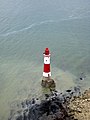 Lighthouse at Beachy Head.
 -
 Beachy Head and lighthouse.
 -
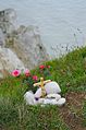 Flowers laid at the cliff edge.
 -
Close up of Beachy Head lighthouse.
-
 Top of lighthouse, detail.
 -
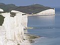 Seven Sisters, with Beachy Head in the distance.
 -
Image of the Belle Tout lighthouse.


External links
- Beachy Head - a page from Eastbourne's official website
- Beachy Head walk to East Dean
- Beachy Head Chaplaincy Team
- The Belle Toute Lighthouse Preservation Trust An organisation being formed to purchase and maintain the Belle Toute lighthouse as well as open it to the public