
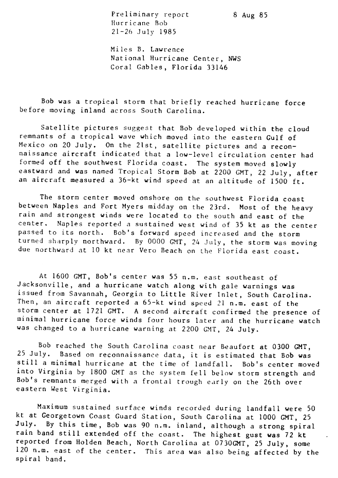
Hurricane Bob (1985)
| Category 1 hurricane (SSHWS/NWS) | |
.JPG) Bob nearing South Carolina landfall as a hurricane | |
| Formed | July 21, 1985 |
|---|---|
| Dissipated | July 26, 1985 |
| Highest winds | 1-minute sustained: 75 mph (120 km/h) |
| Lowest pressure | 1002 mbar (hPa); 29.59 inHg |
| Fatalities | 5 indirect |
| Damage | $20 million (1985 USD) |
| Areas affected | Florida, South Carolina, North Carolina, Virginia |
| Part of the 1985 Atlantic hurricane season | |
Hurricane Bob was a minimal hurricane that affected the southeast United States in July 1985. The second tropical storm and first hurricane of the 1985 Atlantic hurricane season, Bob developed from a tropical wave on July 21 in the eastern Gulf of Mexico. Afterwards, Bob began moving eastward, finally striking southwestern Florida as a minimal tropical storm. Bob then turned to the north, and quickly intensified to attain hurricane status on July 24. The next day, it made landfall near Beaufort, South Carolina, becoming one of a record-tying six hurricanes to hit the United States in a hurricane season, something that had not happened since 1916.[1] Bob quickly weakened over land, and was absorbed by a frontal trough over eastern West Virginia on July 26.
Throughout its path, Bob caused $20 million in damage (1985 USD, $37.6 million 2006 USD) and five indirect deaths from traffic fatalities. In Florida, the storm produced heavy rainfall, including over 20 inches (500 mm) in Everglades City. Along most of its path, the rainfall was beneficial due to lower-than-normal rainfall throughout the year. Damage was minimal in South Carolina where the hurricane made landfall. In Virginia, the storm spawned three tornadoes, one of which destroyed two houses.
Storm history

Tropical storm (39–73 mph, 63–118 km/h)
Category 1 (74–95 mph, 119–153 km/h)
Category 2 (96–110 mph, 154–177 km/h)
Category 3 (111–129 mph, 178–208 km/h)
Category 4 (130–156 mph, 209–251 km/h)
Category 5 (≥157 mph, ≥252 km/h)
Unknown
The remnants of a tropical wave entered the southeastern Gulf of Mexico on July 20. An area of low pressure formed, and following the formation of a low-level circulation, it developed into a tropical depression on July 21, while located 200 miles (320 km) west-northwest of Naples, Florida. Under weak steering currents, the tropical depression drifted to the southeast, then turned to the northeast, and later to the east. Based on reports from Hurricane Hunters, it is estimated the system intensified into Tropical Storm Bob late on July 22, while located 125 miles (200 km) west-northwest of Naples. Bob failed to organize significantly while tracking eastward through the Gulf of Mexico, and made landfall between Naples and Fort Myers, Florida on July 23 as a 45 mph (70 km/h) tropical storm, with most of the convection located to the south and east of the center.[2]
While moving across Florida, Bob turned to the northeast, then to the north; subsequently, it left the peninsula, moving into the Atlantic Ocean early on July 24 near Vero Beach. As it moved over the warm waters of the Gulf Stream, it quickly strengthened and organized, and Bob intensified into a Category 1 hurricane late on the 24th, while located 70 miles (115 km) east of Jacksonville, Florida.[2] Because it was embedded within the western extension of the subtropical ridge, Bob retained higher than normal pressures throughout its lifespan, and its minimum central pressure was 1002 mbar (29.59 inHg).[3] The hurricane continued northward, and made landfall near Beaufort, South Carolina early on July 25, carrying winds of 75 mph (120 km/h). Bob quickly weakened over land, decaying into a tropical storm three hours after landfall, and degenerating into a tropical depression after the passage of another 12 hours, near the North Carolina/Virginia border. It turned to the north-northeast, and was absorbed by a frontal trough over eastern West Virginia on July 26.[2] Its area of disturbed weather remained separate from the trough, and continued northeastward through the Mid-Atlantic and New England while moving around a ridge to its southeast.[4]
Preparations
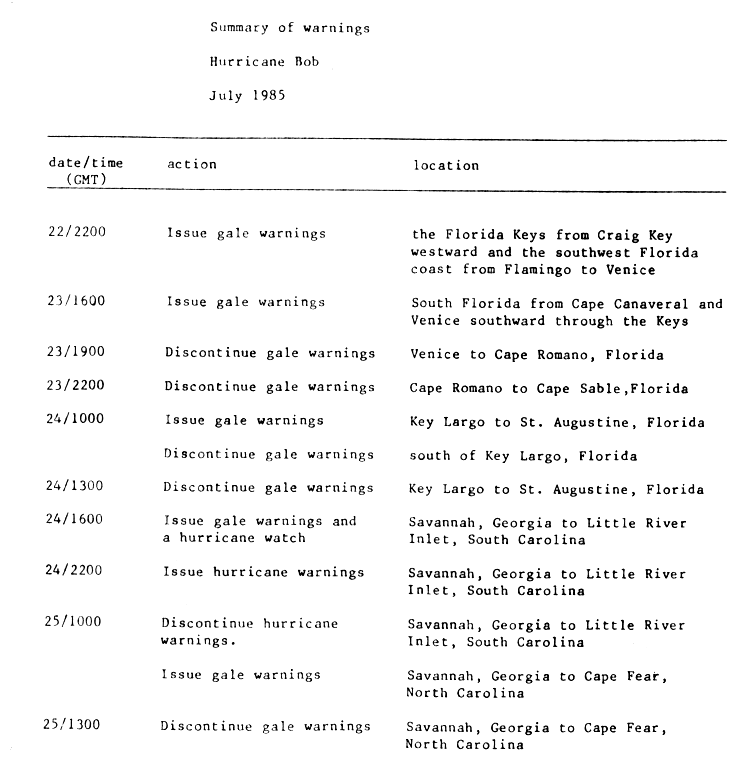
When Bob became a tropical storm, the National Hurricane Center issued gale warnings for the Florida Keys west of Craig Key, and also from Flamingo to Venice. Gale warnings were later issued for the Atlantic coast of Florida northward through St. Augustine.[5] Small craft were advised to remain at port south of St. Augustine.[6] While located off the east-central coast of Florida, the National Hurricane Center issued a gale warning and a hurricane watch from Savannah, Georgia to Little River, South Carolina. After Bob intensified into a hurricane, the hurricane watch was upgraded to a hurricane warning.[2]
Thousands of people evacuated coastal areas of South Carolina, many of which stayed at inland hotels; 850 people stayed at shelters, including 500 at an elementary school in Horry County and 240 in a shelter in the Grand Strand. In Beaufort County, where the storm came ashore, officials closed city and county offices early, and advised businesses to send their workers home early on the day of Bob's landfall. Officials in Chatham County, Georgia evacuated nursing homes on Tybee Island, and recommended others to leave, due to high tides potentially isolating the island by cutting off U.S. Highway 80. As a result, around half of the island was expected to leave.[7]
Impact
Throughout its path, Hurricane Bob left $20 million in damage[8] and five indirect deaths.
Florida
.JPG)
In south Florida, rainfall remained to the south and east of the center, and the most rainfall associated with the passage of Bob through the area was 21.5 inches (546 mm) in Everglades City.[3] Most other areas in southern Florida received over 3 inches (75 mm), while in the northern portion of the state areas reported between trace amounts to 3 inches (75 mm) of precipitation.[4] The storm produced light to moderate wind speeds. Naples recorded sustained winds of 40 mph (65 km/h) and a peak gust of 58 mph (94 km/h).[3] Rough surf and higher than normal tides[9] produced moderate to severe beach erosion in portions of Manatee, Sarasota, and Charlotte Counties.[10] While still over the open Gulf of Mexico, Tropical Storm Bob spawned an F0 tornado in Brevard County. A narrow tornado, it caused $2,500 in damage (1985 USD, $4,700 2006 USD) along its 1 mile (1.6 km) path.[11][12]
The passage of Tropical Storm Bob led to flooded roads and downed trees,[13] one of which damaged a car. Rough seas broke over sea walls in southwestern Florida. High tides and heavy rain caused flooding on the causeways to Sanibel Island and Marco Island, leaving the islands temporarily isolated when officials closed the causeways. The roads were re-opened when the waters subsided[6] though the causeway to Sanibel Island was damaged by the storm.[14] High waters in Sanibel Island flooded docks and a store on the marina, and several boats nearly sank. Moderate wind gusts left 1,200 to 1,500 people without power during the storm.[6] In Palm Beach County, rainfall from the storm caused some agricultural damage.[15] Bob was one of only four tropical cyclones to affect Palm Beach County in the month of July since 1878.[16] Overall, damage was minimal and was primarily confined to minor property damage near the coast. The rainfall from the storm was beneficial, as rainfall across the state had been below normal throughout the year.[6] In northeastern Florida into Georgia, the passage of the storm resulted in beach erosion along the coast.[3]
Carolinas, Mid-Atlantic, and New England

The strongest winds of Hurricane Bob were to the east of the center. Georgetown, South Carolina, located 105 miles (165 km) northeast of the storm's landfall, recorded sustained winds of 58 mph (94 km/h), the highest sustained wind reported by a coastal station. A spiral rainband produced a peak wind gust of 83 mph (133 km/h) in Holden Beach, North Carolina, located about 175 miles (280 km) from where the storm made landfall. Upon making landfall, the hurricane produced an estimated storm tide of 2.6 feet (0.8 m) in Edisto Beach, South Carolina.[3] Rainfall in the Carolinas was moderate, with coastal locations of South Carolina receiving over 5 inches (127 mm) of rain.[4] Myrtle Beach reported a state peak of 7.79 inches (198 mm).[3] Much of North Carolina received over 1 inch (25 mm) of rain from the storm, with over 7 inches (180 mm) recorded in Beaufort County, North Carolina.[4]
Hurricane force wind gusts downed trees and power lines, leaving over 32,000 people without power including over 25,000 in the Charleston area. Near the coast, the winds shattered windows of several houses.[17] Strong waves surpassed sea walls in Charleston, spilling floodwaters onto coastal streets and homes.[18] Damage in the state was minimal, and no one was injured.[17] In North Carolina, the storm caused one traffic fatality.[19]
In Virginia, a large band of thunderstorms from the center produced strong winds and led to the formation of three tornadoes. A funnel cloud formed in Albemarle County, and after crossing into Greene County it developed into an F3 tornado. It destroyed two houses and uprooted several trees,[20] causing $250,000 in damage (1985 USD, $470,000 2006 USD).[21] The unsettled conditions spawned an F0 tornado in Goochland County, which tore down a large oak tree, and an F0 tornado in Hanover County.[20] The two weak tornadoes damaged a total of ten houses. Funnel clouds were reported throughout the Baltimore-Washington Metropolitan Area.[22]
Heavy rains and winds caused disruptions at a major Boy Scouts of America gathering outdoors near Fredericksburg, Virginia, where hundreds of tents collapsed. One scout was struck by a falling gateway. Several others received minor cuts and bruises, though no one was seriously injured.[23] The rainfall and gusty winds, including a report of 48 mph (77 km/h) at the Ronald Reagan Washington National Airport, downed trees and power lines, leading to a loss of power to 30,000 people near the Washington, D.C. area[22] and 125,000 in Baltimore.[23] Moderate winds downed a sea plane near Hains Point in the Washington Channel.[22] Rough seas from the remnants of Bob capsized a few boats along the Potomac River. Moderate rainfall cancelled a Richmond Braves game[24] and collapsed a house under construction in Great Falls, Maryland.[22] The passage of the remnants of Bob severely damaged a dam in northeastern Virginia.[25] Slick roads led to several traffic accidents, killing one person in Washington, D.C. and three in Maryland.[22]
In the Mid-Atlantic, Bob produced light rain of around 1 inch (25 mm), with some isolated locations reporting over 3 inches (75 mm). Southeastern New England generally received around 1 inch (25 mm) of rain from the remnants of Bob, though central Connecticut reported over 3 inches.[4] The remnants of Bob produced a half-inch (12 mm) of rain in Atlantic City, New Jersey in just 10 minutes.[23] In Maryland, where dry conditions existed, the rainfall was beneficial.[26]
See also
References
- ^ Hurricane Research Division (2006). "Hurdat Data for Tropical Cyclones 1851-2005". NOAA. Retrieved 2006-11-25.
- ^ a b c d Miles B. Lawrence (1985). "Hurricane Bob Preliminary Report Page 1". National Hurricane Center. Retrieved 2006-10-29.
- ^ a b c d e f Robert A. Case (1986). "Atlantic Hurricane Season of 1985" (PDF). National Hurricane Center. Retrieved 2006-10-29.
- ^ a b c d e David Roth (2005). "Rainfall Data for Hurricane Bob". Hydrometeorological Prediction Center. Retrieved 2006-10-29.
- ^ Miles B. Lawrence (1985). "Hurricane Bob Preliminary Report Page 4". National Hurricane Center. Retrieved 2006-10-29.
- ^ a b c d Associated Press. "Tropical storm Bob hitting Florida hard". Retrieved 2006-10-29.
{{cite news}}: Unknown parameter|publishdate=ignored (help) - ^ Associated Press. "Hurricane Bob Batters Georgia-South Carolina Coast". Retrieved 2006-10-29.
{{cite news}}: Unknown parameter|publishdate=ignored (help) - ^ Department of the Army (2004). "Chapter 8: Civil Works - DAHSUM FY 1985". Retrieved 2006-10-30.
- ^ Mike Kelly. "Ideal for baking in sun's rays". Syracuse Herald Journal. Retrieved 2006-10-29.
{{cite news}}: Unknown parameter|publishdate=ignored (help) - ^ Florida Department of Environmental Protection (2000). "Status of Beaches in Southwest Florida" (PDF). Retrieved 2006-10-29.
- ^ Tom Grazulis & Bill McCaul (2005). "Every Hurricane that has Spawned a Tornado". The Tornado Project. Retrieved 2006-10-29.
- ^ National Climatic Data Center (2005). "Event Report for Florida". Retrieved 2006-10-29.
- ^ Mike Kelly. "South wind to bring steamy heat". Syracuse Herald Journal. Retrieved 2006-10-29.
{{cite news}}: Unknown parameter|publishdate=ignored (help) - ^ Lee County Planning Division (1999). "PAT 98-40 BoCC Sponsored Amendment to the Lee County Commprehensive Plan" (PDF). Retrieved 2006-10-29.
- ^ Palm Beach County Government (2004). "Historical Chronology of Palm Beach County Flood Events". Retrieved 2006-10-29.
- ^ Rochelle Brenner Gilken & Associated Press (2005). "Dennis poses threat to Florida". Palm Beach Post. Retrieved 2006-10-29.
- ^ a b Associated Press. "Bob leaves thousands homeless". Retrieved 2006-10-29.
{{cite news}}: Unknown parameter|publishdate=ignored (help) - ^ United Press International. "Hurricane Bob blasts S.C. coast". Retrieved 2006-10-29.
{{cite news}}: Unknown parameter|publishdate=ignored (help) - ^ Miles B. Lawrence (1985). "Hurricane Bob Preliminary Report Page 2". National Hurricane Center. Retrieved 2006-10-30.
- ^ a b Wakefield and Blacksburg, Virginia National Weather Service (2006). "Virginia Hurricane History". Retrieved 2006-10-30.
- ^ National Climatic Data Center (2006). "Event Report for Virginia". Retrieved 2006-10-30.
- ^ a b c d e David Roth & Hugh Cobb (2001). "Late 20th Century Virginia Hurricane History". National Weather Service. Retrieved 2006-10-30.
- ^ a b c Associated Press. "Remnants of Hurricane Bob drops heavy rains on Northeast". Retrieved 2006-10-30.
{{cite news}}: Unknown parameter|publishdate=ignored (help) - ^ Mike Kelly. "Hurricane Bob just splash in the pan". Retrieved 2006-10-30.
{{cite news}}: Unknown parameter|publishdate=ignored (help) - ^ Virginia Department of Game and Inland Facilities (2005). "Gardy's Millpond". Retrieved 2006-10-30.
- ^ David Lesher. "Hurricanes' remnants often give Maryland problems". The Frederic Post. Retrieved 2006-10-29.
{{cite web}}: Unknown parameter|publishdate=ignored (help)
External links
Tropical cyclones of the 1985 Atlantic hurricane season | ||
|---|---|---|
 | ||