Florida Keys
| Florida Keys | ||
|---|---|---|
| Satellite image of the Florida Keys | ||
| Waters | Gulf of Mexico | |
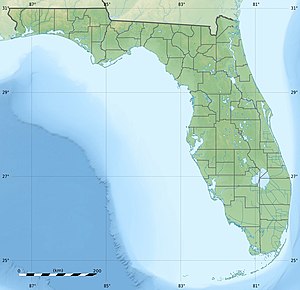
| Geographical location | 24 ° 40 ′ N , 81 ° 33 ′ W | |
|
|
||
| Number of islands | over 200 | |
| Total land area | 355.6 km 2 | |
The Florida Keys are a chain of over 200 coral islands with a total length of over 290 kilometers (180 miles). They are located off the southern tip of the Florida peninsula between the Gulf of Mexico and the Atlantic Ocean . The name is derived from the Spanish word Cay for sand island (on a coral reef ).
Until a hurricane in 1935 , the islands were connected by a railroad . Today the islands are connected by the 42 bridges of the Overseas Highway , which was built in place of the railway line and extends to Key West . The most famous of the bridges is the " Seven Mile Bridge ". It connects Vaca Key ( marathon ) with Bahia Honda and crosses Pigeon Key. According to its name, this bridge is seven miles (eleven kilometers) long.
The remote and uninhabited islands of the Marquesas Keys (about 50 kilometers west of Key West) and the Dry Tortugas (113 kilometers west of Key West), which mark the actual end of the Florida Keys in the west, can only be reached by boat . The third largest tropical coral reef in the world extends underwater .
Climate and geology
climate
The Florida Keys are located between 24 and 25 degrees north latitude and are therefore in a tropical area. The climate, flora and fauna are closer to the conditions in the Caribbean than in the rest of Florida, although the Caribbean islands are of volcanic origin. The Florida Keys have a tropical climate. It is also very much shaped by the Gulf Stream , which brings warm water from the tropical area of the Caribbean to the north.

The average daytime temperatures in Key West from May to October are up to 32 ° C. The coldest months from December to February, however, with average daytime temperatures of 24 ° C, are still more warm than midsummer in Germany (23 ° C). In summer, the high humidity in particular means that the perceived temperatures are well above the actual temperature.
They are the only frost-free place in Florida. There are two different weather periods: humid, hot and humid from June to October and drier and cooler from November to May. Furthermore, Key West is located in the middle of the Atlantic hurricane zone and is therefore frequently hit by hurricanes . Statistically it rains in the summer months - even if only briefly - on an average of 40% of the days.
|
Monthly average temperatures and rainfall for Key West, Florida
Source: weather.com
|
|||||||||||||||||||||||||||||||||||||||||||||||||||||||||||||||||||||||||||
geology
The Florida Keys are the visible parts of an ancient coral reef. The northernmost island of this reef is Elliott Key in Biscayne National Park . North of Elliott Key there are several transition islands that have formed from sand on remnants of the old coral reef. Key Biscayne and islands further north have been formed from sandbanks.
The Florida Keys took on their current shape as a result of drastic changes in water levels as a result of the ice ages. About 125,000 years ago, in the Sangamon interglacial period, which corresponds to the European Eem warm period , the sea level began to rise by 7.5 m to 8 m above its current level. South Florida was a shallow lake at the time. Several parallel reefs formed south of flooded Florida, starting roughly near present-day Miami to the area known as the Dry Tortugas . Key Largo protrudes from this limestone reef . The uppermost rock layer of today's Upper Keys was formed from the limestone of the coral reefs of that time, while the reef foundations and the islands of the Lower Keys were formed from the limestone of calcareous algae .
About 100,000 years ago, during the Wisconsin Ice Age, sea levels began to drop, causing the coral reef and surrounding sediments to protrude from the ocean. 15,000 years ago the sea level sank 110 m below today's level. The reef parts and deposits protruding from the sea eroded very severely. Over-acidic water, presumably caused by dying vegetation, began to dissolve the limestone. The dissolved limestone was partially redeposited as gypsum . The eroded limestone formed oolites in the shallow sea adjacent to the reef and, together with the skeletal remains of bog animals, formed the surface that makes up southern Florida and the Lower Keys from Big Pine Key to Key West . To the west of Key West, the ancient reef is covered by sand-lime sand.
history
Early settlement
The earliest settlement of the Florida Keys was likely by Indians of various tribes, including the Vescayos , Matecumbes, and Tequesta , followed by the Florida-based Calusa and Seminoles and perhaps Caribbean tribes. They lived nomadically in the Keys and traveled with pirogues , early dugout-like boats. They used the Keys as fishing grounds for fish, sea turtles , manatees and clams. The oldest finds of piles of rubbish made of fish bones and mussel shells can be dated back to around 800 AD, although a much earlier settlement is assumed.
Modern discovery and shipwrecks

In 1513 the Florida Keys were discovered by the Spaniard Juan Ponce de León , who spotted them in search of the legendary fountain of youth and named them "Los Martires" (the martyrs) because of their appearance. For the Spaniards, however, the islands were of little interest, as there was little drinking water and fertile soil for settlement; there were also no natural resources to be discovered. Individual missionaries from Havana tried to convert the local Indians to Catholicism and at the same time to teach them to hate the warring English and French - the main interest of the Spaniards on the islands, however, was solely the protection of the fleets that pass through this area on the journey to Spain had to. Unlike other Caribbean islands, which developed into Spanish trading centers at that time, the islands remained largely uninhabited during their 250-year membership in Spain until the 18th century.
Due to its location on the edge of the Florida Strait , a shipping lane that has been heavily used since the beginning of European colonization, the coral reefs of the Florida Keys have seen a large number of shipwrecks. So sank in 1622, the Spanish galleon Nuestra Señora de Atocha (short Atocha ) to the Florida Keys after by a hurricane was surprised. The ship, laden with gold, silver and jewels, was not rediscovered until 1985 by the treasure hunter Mel Fisher . Some of the finds from the Atocha wreck can be seen in the Mel Fisher Maritime Heritage Society Museum in Key West. In 1733, all but one of the 22 ships in a silver fleet sank when a hurricane drove it against the coral reefs of the Florida Keys. In the sinking, however, many crew members were able to save themselves and the Spaniards were able to recover most of the treasures on board. In the 1930s, the diver Art McKee discovered the remains of the sunken fleet. The site of one of the 1733 Silver Fleet wrecks is protected as an Underwater Archaeological Preserve State Park .
Settlement in the 18th century
It was not until the 18th century that the islands were more intensely settled by immigrants from the Bahamas who came here to cut wood and hunt for turtles. The settlers brought parts of their culture to the Keys, including a culinary fondness for the giant wing snail ( Strombus gigas ), the "Queen Conch". The name for long-time residents of the Keys, who are referred to as "Conch", is also derived from the English name.
Around 1820 there was the first more intensive settlement on Cayo Hueso, today's island of Key West . This was due to the island's natural deep-water harbor, which was better situated than the Port of Miami , which is hampered by the four-meter shoal of Biscayne Bay . The so-called “wrecker” settled in Key West and went into the sea on boats to help ships run across the reefs or to salvage their cargo. However, individual wreckers probably also lured ships unfamiliar with the location to the reefs with false lights. The profitable activity of the wrecker decreased with the placement of fixed ships with illuminated signs at key points of the reefs, which were replaced by lighthouses around 1850. In addition to the wreckers, sponge diving and turtle trapping, and probably piracy, were also profitable.
In the 19th century, families also settled on government land and lived on the cultivation of pineapples , melons and coconut palms as well as fishing as self-sufficient . They traveled between the islands in flat boats and carried their goods to the port of Key West.
Railroad Construction and Overseas Highway
In 1893, the Florida East Coast Railway's certificate of approval was changed to allow for a possible extension of the line to Biscayne Bay and then across the Florida Keys to Key West. The President of the Florida East Coast Railway, Henry Flagler , initiated the construction of the railway line from Homestead across the Everglades and over 30 islands of the Florida Keys to Key West, construction of which began in 1904. At the time, Key West was the US port closest to the Panama Canal , and there was also brisk trade with Cuba .
The railway line, known as the Key West Extension , was built over seven years and cost about $ 27 million. The work was strongly influenced by the swamps and mosquito plagues. In September 1906, a hurricane destroyed the Long Key Viaduct that had started, killing more than 100 workers. In 1907 this more than 3 km long bridge was opened and made the connection to Knights Key. Storm damage occurred again in 1909 and 1910. On January 22nd, 1912, the first train actually went to Key West. On September 2, 1935, however, the Labor Day hurricane , which killed more than 800 people, washed away large parts of the embankment and the tracks over a length of 65 km, and much of the route was in ruins. Most of the bridges had survived the storm, but the costs of rebuilding the unprofitable route were too high and the motivation too low. In addition, the car established itself as a new means of transport and prevailed in the field of passenger transport. The government bought the remaining bridges for about $ 640,000 and built the Overseas Highway as the first section of US Highway 1 on the basis of the railway line . From the 1970s onwards, the old railway bridges were replaced by new concrete bridges built next to them.
In September 2017, Hurricane Irma caused severe damage to the Florida Keys.
Flora and fauna

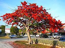
Exceptional plants and animal species exist on the Keys that are not found in this form in the USA. The Keys form the northernmost point of their distribution. The climate allows many imported plants to thrive. Almost every pot flower and southern plant thrives in the Keys climate. Some exotic plants are increasingly conquering the natural habitat. Many plants slow down or stop growing in the drier weather period. Many native trees are deciduous and lose their leaves during this time.
Both conifers and hardwoods are native to the Keys. Here you can find maple, pine and oak, which are located at the southernmost edge of their occurrence, and tropical woods such as mahogany, bursera, eugenia and many others, which otherwise only thrive between the 25th and 26th parallel north.
Many plants, such as the triple flower, the coconut tree, hibiscus and papaya, are not native but imported. The lime, for example, after which the typical regional dessert key lime pie is named, was introduced from the Yucatán Peninsula . Originally from Malaysia . Their trees are fast growing and have thorns. The golf ball-sized fruits have an unmistakable scent.
The Keys are also home to some distinctive animal species, such as the protected Key white-tailed deer and the American crocodile . 110 km west of Key West are the Dry Tortugas with the Dry Tortugas National Park , one of the most isolated and best protected protected areas in the world. The name was given to them by Spanish conquerors because of the lack of drinking water and their hunched shape, which from a distance make them look like a turtle.
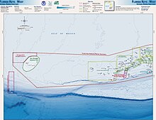
The ocean around the Keys is part of the Florida Keys National Water Reserve .
In August 2020, the Florida Keys Mosquito Control District approved a pilot project to release genetically modified mosquitoes in the Florida Keys. According to this, millions of such male mosquitoes will be released in 2021, which, unlike the females, do not bite. The genetic change in a protein makes the female offspring incapable of survival in the course of mating. Thus, the population of female mosquitoes, which are responsible for transmitting diseases such as dengue fever and Zika virus , can be reduced. The biotechnology company Oxitec , which supplies the genetically modified mosquitoes , has already carried out such projects successfully on the Cayman Islands and in Brazil. Studies by various US government agencies, such as the Environmental Protection Agency , have confirmed and thus approved the safety of the project. Keys Mosquito Board members voted 4-1 in favor of the project despite concerns from the Florida Keys Environmental Coalition director's concerns about unintended environmental impacts.
List of islands
The Florida Keys are made up of more than 200 flat islands called cays or keys. The northernmost island of the Florida Keys is Elliott Key , to the north of this, however, there are still some transition islands, which consist of sand over former reef areas. Key Biscayne and some other islands north of the Keys, on the other hand, are completely formed from former sandbanks .
The islands of the Florida Keys are divided into three groups:
- Upper Keys
Keys in Biscayne National Park in Miami-Dade County :
- Transitional islands
- Real Florida Keys, exposed ancient coral reefs
Keys in Monroe County
- Middle Keys
- Plantation Key (with Tavernier )
- Craig Key
- Fiesta Key
- Long Key (formerly known as Rattlesnake Key)
- Conch Keys
- Duck Key
- Grassy Key
- Crawl key
- Long Point Key
- Fat Deer Key
- Shelter Key
- Boot Key
- Knight's Key
- Pigeon Key
- Matecumbe Key ( Upper and Lower )
- Crawl key
- Key Vaca (with marathon )
- Lower Keys
- Little Duck Key
- Missouri Key
- Ohio Key (also known as Sunshine Key)
- Bahia Honda Key
- Spanish Harbor Keys
- Scout Key (formerly known as West Summerland Key)
- No Name Key
- Big Pine Key
- Little Torch Key
- Middle Torch Key
- Big Torch Key
- Ramrod Key
- Summerland Key
- Knockemdown Key
- Cudjoe Key
- Sugarloaf Key
- Park Key
- Saddlebunch Keys
- Shark Key
- Geiger Key
- Big Coppitt Key
- East Rockland Key
- Rockland Key
- Boca Chica Key
- Key Haven (Raccoon Key)
- Stock Island
- Key West (with the city of the same name, Key West )
- Sigsbee Park
- Fleming Key
- Outlying islands that can only be reached by boat
literature
- Stephen Frinck and William J. Harrigan: Florida Keys Dive Guides . Jahr Verlag, Hamburg 1997. ISBN 3-86132-245-5 .
- Jeff, Ripple (1995). The Florida Keys: the Natural Wonders of an Island Paradise , Photographs by Bill Keogh, Stillwater , Minnesota : Voyageur Press. ISBN 0-89658-262-0 .
Web links
- US National Park Service Info: Dry Tortugas
- Jason Project The Story of Water Movement and Land Formation
- About the Florida Keys
- Köppen Climate Classification Map
Individual evidence
- ^ Monthly Averages for Key West. weather.com, accessed May 17, 2010 .
- ↑ a b c d e f g h i Stephen Frinck, William J. Harrigan: Florida Keys - Diving Guide. Jahr Verlag, Hamburg 1997. ISBN 3-86132-245-5 .
- ^ A b "Historical Evolution" In: Nancy Toppino: Insiders' Guide to Florida Keys and Key West. Globe Pequot, 2009; Pp. 3-10.
- ↑ Florida Keys to release modified mosquitoes to fight illness. In: Associated Press. August 20, 2020, accessed on August 22, 2020 .


