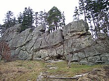
Čertovy skály
The natural monument Čertovy skály (German: Devil's Stone , also Čertovy stěny , Devil's Walls) is a 0.15 hectare large sandstone formation marked by strong water erosion , which is also called Magura Flysch in this area . The natural monument is located in the east of the Vizovická vrchovina on the southeast slope of the Kopce elevation on the left side above the valley of the Senice river at an altitude of between 450 and 490 mnm. It is a 150 m long, up to 25 m high and 1 to 3 m wide sandstone massif . Four rocks protrude from the ridge (Hladká, Čertova stěna, Plochá and Kolébka).
The flora is quite sparse and the rock is largely bare. Scots pine (Pinus sylvestris), silver birch (Betula pendula), common juniper (Juniperus communis), red elder (Sambucus racemosa), blueberry (Vaccinium myrtillus), northern striped fern (Asplenium septentrionale murorum ), forest hawkweed (Hieracium murorum) ), Silver cinquefoil (Potentilla argentea), St. John's wort (Hypericum perforatum), common stalk grass (Anthoxanthum odoratum), small brown elk (Prunella vulgaris), forest lady fern (Athyrium filix-femina), common worm fern (Dryopteris filix-mas) and Bracken (Pteridium aquilinum). An investigation into the fauna has not yet been carried out.
The Čertovy Skály are an important climbing garden and one of the most difficult climbing areas in Moravia. Most of the over 100 routes were mainly developed in the 1960s to 1980s and range up to level IX (UIAA) . Climbing is restricted for nature conservation reasons and is only allowed for members of alpine associations ( UIAA ).
Some folk legends are linked to the formation, all of which have different events with a devil as their content and are possibly responsible for the name.
swell
- nature.hyperlink.cz - (Czech)
- zajimavosti.beskydy.cz (Czech and English)
Web links
Individual evidence
- ↑ a b Vladimír Skýpala, Vladimír Wolf: Moravské skály . 2002, p. 164 .
- ↑ Vladimír Skýpala, Vladimír Wolf: Moravské skály . 2002, p. 5 .
Coordinates: 49 ° 13 ' N , 18 ° 3' E
