Łomża (rural municipality)
| Gmina Łomża | ||
|---|---|---|

|
|
|
| Basic data | ||
| State : | Poland | |
| Voivodeship : | Podlaskie | |
| Powiat : | Łomżyński | |
| Geographic location : | 53 ° 10 ' N , 22 ° 5' E | |
| Height : | 95 m npm | |
| Residents : | 10,771 | |
| Gmina | ||
| Gminatype: | Rural community | |
| Gmina structure: | 43 localities | |
| 40 school offices | ||
| Surface: | 207.41 km² | |
| Residents: | 11,099 (Jun. 30, 2019) |
|
| Population density : | 54 inhabitants / km² | |
| Community number ( GUS ): | 2007022 | |
| Administration (as of 2014) | ||
| Wójt : | Piotr Kłys | |
| Address: | M. Curie-Skłodowskiej 1A 18-400 Łomża ul |
|
| Website : | www.lomza.powiatlomzynski.pl | |
The gmina wiejska Łomża is an independent rural municipality in Poland in the powiat Łomżyński in the Podlaskie Voivodeship . Its headquarters are in the independent city of Łomża .
geography
Geographical location
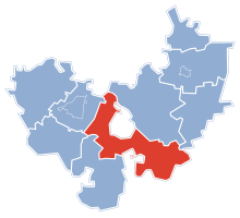
The rural commune ( Gmina ) includes the city of Łomża in the west, south and east. It forms the center of the Powiat Łomża.
Community structure
Schulzenämter
- Andrzejki
- Bacze search
- Boguszyce
- Bożenica
- Chojny Młode
- Czaplice
- Dłużniewo
- Gać
- Giełczyn
- Grzymały Szczepankowskie
- Janowo
- Jarnuty
- Jednaczewo
- Kisiołki
- Konarzyce
- Koty
- Lutostań
- Łochtynowo
- Mikołajki
- Milewo
- Modzele-Skudosze
- Modzele-Wypychy
- Nowe Kupiski
- Nowe Wyrzyki
- Pniewo
- Podgórze
- Puchały
- Rybno
- Siemień Nadrzeczny
- Siemień-Rowy
- Sierzputy Młode
- Stara Łomża nad Rzeką
- Stara Łomża przy Szosie
- Stare Chojny
- Starlings Kupiski
- Stare Modzele
- Starlings Sierzputy
- Wygoda
- Zawady
- Zosin
Locations without a Schulzenamt
history
In the course of the 3rd partition of Poland , the region came to Prussia in 1795 . In 1807 it became part of the Duchy of Warsaw installed by Napoleon and in 1815 part of the Congress Poland, which belonged to the Tsarist Empire . Occupied by Germans in 1917 and fought over in the Polish-Soviet War in 1919/1920 , the area became part of the Second Polish Republic .
During the Second World War , the region was occupied by the Soviet Union in 1939 and by the Wehrmacht from 1941 to 1944 . In the forest near Pniewo Jews and Poles were shot by Germans from 1941 to 1943. Up to 400 people are said to be in the mass graves.
From 1975 to 1998 the rural community belonged to the Łomża Voivodeship .
Memorials
- Memorial in the forest near Pniewo
Web links
Individual evidence
- ↑ population. Size and Structure by Territorial Division. As of June 30, 2019. Główny Urząd Statystyczny (GUS) (PDF files; 0.99 MiB), accessed December 24, 2019 .


