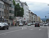
Aachener Strasse (Düren)
The Aachener Strasse in Düren , North Rhine-Westphalia , is a historic main street.
The Aachener Straße is the extension of the federal highway 399 , which leads from the northern Eifel over the Monschauer Straße into the city. It has been expanded to four lanes and begins today at the Johannesbrücke over the Rur and ends at the intersection of Rütger-von-Scheven-Straße / Stürtzstraße / August-Klotz-Straße .
In the past, Aachener Strasse began on Weierstrasse at the wooden gate. The current street name was introduced by the French in 1794. The main connecting road from Düren to Aachen via Eschweiler used to lead via the wooden gate that was laid down in 1822 and Aachener Straße . On March 4, 1822, a joint-stock company was founded specifically to expand the road. It had a capital of 152,400 marks. A barrier was erected at the Rurbrücke in order to be able to collect the toll there. On February 5, 1897, the city bought the road and the road toll was canceled.
From 1908 to around 1957 the tram of the Dürener Kreisbahn (DKB) drove on Aachener Straße. The single-track line led from Markt to Rölsdorf and on to Lendersdorf or Gürzenich. The stops were Holzstraße - Aachener Straße , Jahnstraße and Stadtpark-Rurbrücke , the latter with a siding.
American troops penetrated Düren on February 15, 1945 via the Johannesbrücke and Aachener Strasse .
The entrance to the Annakirmes , which takes place every year at the end of July / beginning of August and is one of the largest folk festivals in Germany, is on the street . The offices of the district police authority are located in three buildings at the confluence of August-Klotz-Straße .
On the opposite side of the street at the confluence of Rütger-von-Scheven-Straße is the listed Wehrmeisterkreuz , a crossroads from 1664.
See also
swell
- Website of the city of Düren (PDF; 58 kB)
- Josef Geuenich: The Düren street names , Düren 1965, published by the city of Düren and the Düren history association
Individual evidence
- ^ Dürener Kreisbahn GmbH (Ed.): 75 years of Dürener Kreisbahn. Düren 1983, p. 14.
Coordinates: 50 ° 47 ′ 49.1 ″ N , 6 ° 28 ′ 36 ″ E

