
Abhaneri
| Abhaneri अभनेरी |
|||
|---|---|---|---|
|
|||
| State : |
|
||
| State : | Rajasthan | ||
| District : | Dausa | ||
| Sub-district : | Baswa | ||
| Location : | 27 ° 0 ′ N , 76 ° 36 ′ E | ||
| Height : | 278 m | ||
| Residents : | 2,104 (2011) | ||
 |
|||

Abhaneri ( Hindi अभनेरी ) is a village with a good 2,000 inhabitants in the Dausa district in the east of the Indian state of Rajasthan . The place is known because of a stepwell from the 8th / 9th centuries. Century.
location
Abhaneri is located near the road between the cities of Jaipur and Agra at an altitude of approx. 278 m above sea level. d. The much-visited Mughal Palace of Fatehpur Sikri is located about 130 km to the east. The climate is warm to hot; Rain (approx. 675 mm / year) falls almost exclusively during the summer monsoon season .
population
The predominantly Hindi- speaking population consists of about 90% Hindus and 10% Muslims ; other religious communities hardly play a role among the rural population of India. In contrast to what is common in northern India, the male and female proportions of the population are roughly the same.
economy
Agriculture has traditionally played the most important role in the entire district of Dausa; tourism is also of minor importance.
history
According to tradition, Raja Mihira Bhoja I (approx. 836-885) from the Pratihara dynasty is considered to be the founder of the formerly important site and the founder of the Chand Baori stepwell and the nearby Harshat Mata temple semi-mythological Raja Chand is equated. The antiquated decor and figure style of the stepwell and the temple rather refers to a time of origin in the 7th or 8th century. During the time of the Islamic advance in northern India, both buildings were largely destroyed in the 10th or 11th century, but in the 16th and 17th centuries. In the 19th century, the place was still so significant that both the stepwell and the temple were partially renewed or rebuilt during this time.
Attractions
_at_Abhaneri.JPG)

- The main attraction of the place is the Chand Baori stepwell , the east side of which with its temple-like buildings mostly dates from the 8th century. The geometrically abstract prism-like edging of the almost 20 m deep well basin, on the other hand, is a renovation measure of the 16th / 17th century. Century ( Mughal period ), which also includes several jagged arcades of the eastern part and the entire upper arcade circumference. In total, the enclosure consists of 13 levels with hundreds of stairs and around 3500 steps. In the niches of the two mighty pillars in the lower part of the fountain there are images of the gods of Durga and Ganesha .
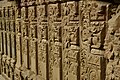
Richly decorated pillars (8th century) on the eastern part of the stepwell with jug motifs ( kalashas ), half and full rosettes and plant decoration
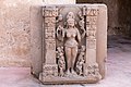
Goddess Durga (?) Standing on a lotus flower , accompanied by servants and framed by two richly decorated pillars with kalasha motifs

Jali window from the time of reconstruction


.JPG)
- For stylistic reasons, the 7th / 8th The Harshat Mata temple, dating from the 16th century, stands on an artificially constructed platform ( jagati ) in the immediate vicinity of Chand Baori ; it was badly damaged during the Muslim conquest of northern India. It may originally have been dedicated to Vishnu , but a later local tradition assigned it to the regionally revered lucky goddess Harshat Mata . When the temple was rebuilt in the 16./17. In the 19th century, both the open pillared hall ( mandapa ) and the all-round closed and windowless cella ( garbhagriha ) received dome roofs in the late Mughal style. In the vicinity of the temple there are hundreds of hewn stones that could have come from a former Shikhara tower above the cella.
literature
- Morna Livingston, Milo Beach: Steps to Water. The Ancient Stepwells of India. Princeton Architectural Press 2002, ISBN 1-56898-324-7 .
Web links
- Abhaneri, Chand Baori videos
- Abhaneri, Harshat Mata Temple - Video
- Abhaneri, Harshat Mata Temple - Photo + Info (English)
- Abhaneri, Harshat Mata Temple - Photo + Info (English)
- Abhaneri, Harshat Mata Temple - Photo