Achim (Börßum)
|
Achim
community Börßum
|
||
|---|---|---|
| Coordinates: 52 ° 3 ′ 38 ″ N , 10 ° 36 ′ 42 ″ E | ||
| Height : | 91 m above sea level NHN | |
| Area : | 15.81 km² | |
| Residents : | 679 (Dec. 31, 2010) | |
| Population density : | 43 inhabitants / km² | |
| Incorporation : | November 1, 2011 | |
| Postal code : | 38312 | |
| Area code : | 05334 | |
|
Location of Achim in Lower Saxony |
||
|
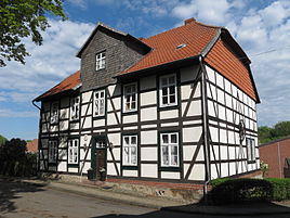
Half-timbered house in Achim
|
||
Achim ( ) is a district of the municipality Börßum in the district of Wolfenbüttel , Lower Saxony .
geography
The place is located southeast of the Oderwald about twelve kilometers south-southeast of Wolfenbüttel , about two kilometers north of the federal highway 82 , which leads from Goslar via Hornburg to Schöningen . This also gives him access to federal motorway 36 .
The Hellebach , coming from the northeast, flows through Achim and joins the Schiffgraben-West to the south of the village .
history
In the middle of the 18th century the Achim office was established in the Principality of Braunschweig-Wolfenbüttel .
According to the decision of the Lower Saxony state parliament on April 13, 2011, the Achim community was incorporated into the neighboring community of Börßum on November 1, 2011 .
On March 1, 1974, the communities Kalme and Seinstedt were incorporated.
coat of arms
Description: In gold (yellow) above a blue wave shield base, a red cross with broadened arms under a blue rafter.
Web links
Individual evidence
- ^ Georg Hassel, Karl Friedrich Bege: Geographical-statistical description of the principalities of Wolfenbüttel and Blankenburg, Volume 1, 1802, p. 416
- ↑ Law on the unification of the municipality of Achim and the municipality of Börßum, combined municipality of Oderwald, district of Wolfenbüttel. April 13, 2011
- ^ Federal Statistical Office (ed.): Historical municipality directory for the Federal Republic of Germany. Name, border and key number changes in municipalities, counties and administrative districts from May 27, 1970 to December 31, 1982 . W. Kohlhammer GmbH, Stuttgart / Mainz 1983, ISBN 3-17-003263-1 , p. 273 .


