Älggi-Alp
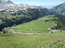
The Älggi-Alp is the largest alp in the municipality of Sachseln in the canton of Obwalden in Switzerland . The geographic center of Switzerland lies on it .
Location and situation
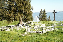
The Älggi-Alp lies at an altitude of 1645 m above sea level. M. in the southern area of the municipality of Sachseln. The formerly marshy high valley is limited to the southeast by a semicircle made up of the peaks Seefeldstock ( 2129 m above sea level ), Chli Haupt and Brünig-Haupt ( 2312 m above sea level ), the Schnidengrätli ( 2114 m above sea level ). and the Schindelegg. Several alpine huts, the mountain inn Aelggialp and the Älggi-Kapelle (Chapel of St. Anne) are scattered on the plateau, surrounded by extensive hillside pastures. The interior of the chapel was made by the Sachsler artist Alois Spichtig . The Älggi-Alp belongs to the Sachseln Corporation . The grazing rights are raffled every 12 years among the corporation citizens who are entitled to use it. The name «Älggi» is derived from Gau , which means plain or flat land. The front part of the name could be an abbreviation of Alp or Allmende .
South of the Älggi-Alp is the Sachsler Seefeld with the Seefeldsee , where trout , char , Namaycush and truffles are fished. From the Älggi-Alp the Älggibach flows in a north-westerly direction into the Kleine Melchtal and the Kleine Melchaa that flows there .
Center of Switzerland
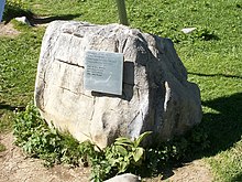
The geographical center of Switzerland lies on the Älggi-Alp, which was measured in 1988 on the occasion of the 150th anniversary of the Federal Office of Topography. This is on the Älggi-Alp at coordinates six hundred sixty thousand one hundred fifty-eight / 183640 . As this point is difficult to access above the cliff of Chli-Älggi, a publicly accessible stone was placed 500 m further southeast. This symbolizes the center and has the coordinates 660 557 / 183 337 .
Every year from 2003 to 2015, the Swiss of the Year was honored at this point and the name was engraved on the existing plaque .
getting there
The Älggi-Alp can be reached via Sachseln by car, on foot or by mountain bike. You can choose the route via Flüeli-Ranft and Wolfisbergstrasse with a beautiful view of the Sarner Aa valley , or you can choose the slightly more winding route via Edisried . The two routes come together at the so-called Blatten . From here on, the access road can only be used alternately uphill and downhill on weekends and public holidays. Driving up is then only permitted during even hours, while driving down is only permitted during odd hours. The 6 km journey takes approximately 20 minutes by car. So you can go down at the latest at 5.40 p.m., for example. Then you have to wait again until the next odd hour.
Web links
- Älggialp Sachseln , operated by the Sachseln Corporation
- Steinmanndli Club , responsible for the center of Switzerland
- Hiking routes to Älggi-Alp ( Memento from May 10, 2013 in the Internet Archive )
Individual evidence
- ↑ corporation Sachseln, Alpwesen information page of cooperation, accessed on September 21, 2012
- ↑ see website Älggialp Sachseln
- ↑ Fischerei im Seefeldsee information page on the website of the Seefeldsee leaseholder association, accessed on March 27, 2018
- ↑ The Center of Switzerland ( Memento from June 6, 2016 in the Internet Archive ), accessed on June 6, 2016


