
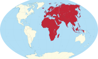
Africa Eurasia
_(W3).svg)
| surface | 84,980,532 km² |
|---|---|
| population | 6,000,000,000 |
| Population density | 70.6 inhabitants / km² |
| countries | 147 |
| Time zones | UTC − 1 ( Cape Verde ) to UTC + 12 ( Russia ) |
The Great Continent Afro-Eurasia , including Afro-Eurasia , Eurafrasien or Europ Africa Rhodesia called, contains the largest contiguous land mass of the Earth .
In biogeography as well as in the humanities and social sciences , this land mass is preferably referred to as the Old World .
Africa-Eurasia is not the same as East Fortress . This outdated term usually includes a. Australia with one.
General

Africa-Eurasia is made up of the continents Africa and Eurasia ( Europe and Asia ). With an area of about 85 million square kilometers, Africa-Eurasia covers one sixth of the earth's surface and comprises well over half of all mainland on earth. With a population of 6.1 billion people (as of 2013), the major continent is home to around 87% of the world's population .
Subdivision
As in the case of Eurasia , many scholars in Africa-Eurasia also argue that the subdivision of the “world island” is not justified and is merely a historical and cultural one. Traditionally, the Isthmus of Suez is seen as the border between Africa and Eurasia .
Emergence
From a geological point of view, Africa-Eurasia is relatively young and has existed in its present form for around 20 million years. After the disintegration of the supercontinent Pangea in the Mesozoic , Eurasia and North America belonged to the "northern continent" Laurasia , while Africa was part of the "southern continent" Gondwana (along with South America, Australia, Antarctica and India), two land masses completely separated from each other by the Tethys Ocean . After the disintegration of Gondwana , Africa and India began to move north in the Cretaceous Period, colliding with Eurasia in the Paleogene and Neogene .
The collision between Africa and Europe will cause the Mediterranean Sea to close in around 50 million years and a mountain range comparable to the Himalayas will rise in its place.
Individual evidence
- ↑ German Foundation for World Population, Info & Service, country database , accessed on January 14, 2011
- ^ Houseman, Greg, "Dispersal of Gondwanaland," University of Leeds, accessed January 14, 2011
- ^ Future World , Christoph Scotese, Paleomap Project, accessed January 14, 2011