
Aldborough (North Yorkshire)
| Aldborough | |||
|---|---|---|---|
 |
|||
| Coordinates | 54 ° 5 ′ N , 1 ° 23 ′ W | ||
| OS National Grid | SE405662 | ||
|
|||
| Residents | 3471 (as of 2001) | ||
| administration | |||
| Part of the country | England | ||
| region | Yorkshire and the Humber | ||
| Shire county | North Yorkshire | ||
| District | Harrogate | ||

Aldborough is a village in the Civil parish Boroughbridge in the Borough of Harrogate in North Yorkshire , England . Originally Aldborough was a parish in the Traditional County of West Riding of Yorkshire in England.
history
Aldborough stands on the site of the British-Roman settlement Isurium Brigantum . The Brigantes were the most important Celtic tribe in this part of Britain and their main town was Isurium Brigantum . The Roman Legio VIIII Hispana was stationed there from 43 AD. The place arose at the important junction of Dere Street , the Roman road connecting Eboracum (now York ) to Veluniate on Antoninuswall (now Bo'ness in Scotland ), with the River Ure , which it crossed here. The Dere Street later became the Great North Road and is now a section of the road A1 .
When the course of the road was relocated after the Norman conquest of England , the place lost a large part of its importance. The road was diverted to the newly created bridge, where a new town grew, which was named New Borough on t'Brigg , Borough on t'Brigg and finally Boroughbridge, while the older town was now called Ald-Borough .
From 1558 to 1832 the parish had two MPs, whom it lost under the Reform Act 1832 .
The Aldborough Roman Museum is part of the English Heritage .
Attractions
- St. Andrew's Church with a relief by Sir William de Aldeburgh (around 1360) on the north side.
- The current town hall dates from the early 10th century and was originally a school building.
- Double pillory with padlocks on The Square.
- Section of the Roman Dere street.
Picture gallery

Sir William de Aldeburgh
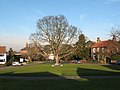
Ortsanger

Aldborough Manor mansion
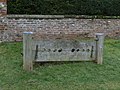
pillory

Dere Street at Aldborough

River Ure at Aldborough


Web links
- Family Search information page (accessed November 10, 2013)
- Aldborough site map (accessed November 10, 2013)
- Aldborough Roman Site on English Heritage (accessed November 10, 2013)