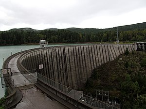
Alder dam
| Alder Dam Alder Lake |
|||||||||||
|---|---|---|---|---|---|---|---|---|---|---|---|
| Alder Dam, Washington | |||||||||||
|
|||||||||||
|
|
|||||||||||
| Coordinates | 46 ° 48 '5 " N , 122 ° 18' 37" W | ||||||||||
| Data on the structure | |||||||||||
| Lock type: | Arch dam | ||||||||||
| Construction time: | 1942-1945 | ||||||||||
| Height of the barrier structure : | 100 m | ||||||||||
| Crown length: | 490 m | ||||||||||
| Crown width: | 4.6 m | ||||||||||
| Base width: | 36.6 m | ||||||||||
| Power plant output: | 50 MW | ||||||||||
| Operator: | Tacoma Power | ||||||||||
| Data on the reservoir | |||||||||||
| Altitude (at congestion destination ) | 368 m | ||||||||||
| Water surface | 12.4 km² | ||||||||||
| Catchment area | 740 km² | ||||||||||
The Alder Dam (English Alder Dam ) is a dam in the US state of Washington , which is used to generate electricity on the Nisqually River .
dam
The dam's arch dam, made of reinforced concrete , is located about 8 km southwest of Eatonville . The dam was built in 1945 and is owned and operated by the regional electricity company Tacoma Power . At the time of completion, the Alder Dam was one of the tallest dams in the United States, at 100 meters high . The dam wall with a total length of 490 meters has a thickness of about 37 meters at the base. There are two turbines in the structure that drive generators with an output of 25,000 kW each. The dam generates around 228 million kWh of electricity annually.
Although the barrier structure of the Alder dam is a dam (English river dam ), the English name "Alder Dam" is usually incorrectly translated as "Alder dam" or "Alder dam" (English embankment dam ). The correct distinction between dam and dam is based on the construction method and the materials used in the construction.
Alder Lake
The dammed lake extends over a length of about 11 km and has a total area of 12.4 km². With 45 km of coastline, the lake is a popular resort with opportunities for water sports and fishing . On the north bank of the lake, east of the dam, the owner has set up Alder Lake Park . The park offers access to the lake and a year-round campsite with 173 spaces. On the eastern edge of the lake is the small town of Elbe . In the vicinity of the lake, about 35 km away, also located stratovolcano Mount Rainier with Mount Rainier National Park .
Naming
The name of the lake and the dam is reminiscent of the former small town of Alder, which was founded in 1905 and had around 200 inhabitants in 1909. After the dam wall was completed in 1945, the place was flooded by the dammed water of the lake and disappeared. When the water level in the lake is low , remains of the settlement can still be seen in some places .
Web links
Individual evidence
- ↑ Alder Dam. Tacoma Public Utilities, accessed April 15, 2020 .
- ↑ Alder Lake Park. Tacoma Public Utilities, accessed April 15, 2020 .
- ↑ Old Alder. Ghost Towns of Washington, accessed April 15, 2020 .
- ↑ Old Alder: Visit before it vanishes. Washington, Our Home, accessed April 15, 2020 .

