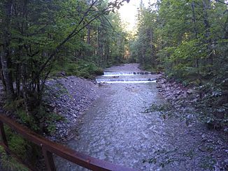
Alpbach (Leitzach)
| Alpbach | ||
|
Alpbach at an altitude of approx. 840 m |
||
| Data | ||
| location |
Northern Limestone Alps
|
|
| River system | Danube | |
| Drain over | Leitzach → Mangfall → Inn → Danube → Black Sea | |
| source | Confluence of Steilenbach and Krottentaler Graben 47 ° 40 ′ 16 ″ N , 11 ° 57 ′ 57 ″ E |
|
| Source height | approx. 840 m | |
| muzzle | At Osterhofen from the left into the Leitzach coordinates: 47 ° 41 '5 " N , 11 ° 58' 52" E 47 ° 41 '5 " N , 11 ° 58' 52" E |
|
| Mouth height | 782 m | |
| Height difference | approx. 58 m | |
| Bottom slope | approx. 28 ‰ | |
| length | 2.1 km | |
The Alpbach is a year-round flowing water in the Mangfall Mountains .
It arises from the confluence of the Stellenbach and Krottentaler Graben , runs largely northward to the confluence with the Leitzach.
Individual evidence
- ↑ Directory of brook and river areas in Bavaria - Inn river area, page 11 of the Bavarian State Office for the Environment, as of 2016 (PDF; 2.8 MB)
Web links
