Altharlingersiel
|
Altharlingersiel
community Neuharlingersiel
Coordinates: 53 ° 41 ′ 11 " N , 7 ° 45 ′ 36" E
|
||
|---|---|---|
| Height : | 2 m above sea level NHN | |
| Incorporation : | July 1, 1972 | |
| Postal code : | 26427 | |
| Area code : | 04974 | |
|
Location of Altharlingersiel in Lower Saxony |
||
Altharlingersiel is a part of the community Neuharlingersiel in the district of Wittmund in East Friesland .
location
Altharlingersiel lies between Neuharlingersiel and Carolinensiel on the Altharlinger Sieltief, which is one of the few natural bodies of water in the flat marshland .
history

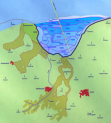
The place was built in 1550 on the edge of the former Harlebucht and served as Sielort for drainage of Falstertiefs, which led to the Harlebucht. The increasing siltation of the outer depths in front of the sluice port led to the abandonment of the port and sluice function and the embankment of another part of the Harle Bay in 1693. To this end, a new sluice port was built around four kilometers north-west of the town in today's Neuharlingersiel.
On February 1, 1972, the previously independent municipality of Altharlingersiel was incorporated into the municipality of Neuharlingersiel together with the municipality of Ostbense .
Since February 6, 1985, the place has been allowed to use the designation "state-approved coastal bathing resort".
Attractions
In the course of the village renewal in 2005, a symbolic harbor wall with a forged railing was created, which traces and clarifies the former course of the historic Sielhafen.
Web links
Individual evidence
- ↑ a b Neuharlingersiel municipality: Altharlingersiel , accessed on April 13, 2014
- ^ Neuharlingersiel: Information about the community Neuharlingersiel , accessed on April 13, 2014
