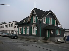
At the decker's house
|
At the decker's house
City of Wuppertal
Coordinates: 51 ° 17 ′ 4 " N , 7 ° 9 ′ 55" E
|
||
|---|---|---|
| Height : | approx. 242 m above sea level NHN | |
|
Location of Am Deckershäuschen in Wuppertal |
||
|
At the decker's house in Wuppertal
|
||
At the Decker house is a local situation in the north of Bergisch city Wuppertal .
Location and description
The location is in the east of the Uellendahl-Ost residential area in the Uellendahl-Katernberg district at an altitude of 242 m above sea level. NHN on today's street Am Deckershäuschen .
Neighboring locations, farms and living spaces are Uellendahl , Uellendahler Brunnen , Am Hammerkloth , Am Hundsbusch , Raukamp , Am Hartkopfshäuschen , Leyenfeld , In den Siepen , Hagebeck , Soltenkopf , Am Sonnenschein and Röttgen .
At the Deckershäuschen it is no longer noticeable as an independent living space, the original settlement has merged into the largely closed development of the Uellendahl-Ost residential area. In addition to residential buildings and larger commercial buildings, the former Evangelical St. Matthew's Church and a Catholic branch church ( Roncalli Center ) are located in the local area .
The Protestant parish of Uellendahl-Ostersbaum gave up the ecclesiastical use of the Matthäuskirche several years ago, and the church premises are to be built on with new residential buildings while preserving the exterior of the church building, the parish hall and the rectory, some of which are being furnished with apartments.
The former church site has been completely rebuilt and inhabited since May 2020. Three apartments have been built in the previous parish hall. The converted Matthäuskirche has been inhabited since April 2016.
history
In the 19th century Am Deckershäuschen belonged to the Uellendahler Rotte of the Lord Mayor's Office of Elberfeld . The place is marked on the topographical survey of the Rhineland from 1824. On the Prussian first recording from 1843 the place is labeled as Decker , on the Wuppertal city map from 1930 with Am Deckershäuschen . Address books from 1850 and from 1864 call the spelling Deckershäuschen and Am Deckershäuschen .
1815/16 there are 18 inhabitants. According to the topographical-statistical description of the Royal Prussian Rhine Province from 1830, 28 inhabitants lived in Deckershäusgen . The place, categorized as a hamlet according to the statistics and topography of the Düsseldorf administrative district in 1832 , was designated as am Deckershäuschen and at that time owned a residential house and an agricultural building. At that time there were 10 people living in the village, two of them Catholic and eight Protestant.
Individual evidence
- ↑ Flyer (PDF; 320 kB) - Information on public participation in the development plan 1137V - Hans-Böckler-Straße / Am Deckershäuschen
- ^ Website of the couple from the ehm. Matthäuskirche - information on the renovation of the former church
- ^ Wolfgang Stock: Wuppertal street names. Their origin and meaning. Thales Verlag, Essen-Werden 2002, ISBN 3-88908-481-8
- ↑ a b Johann Georg von Viebahn : Statistics and Topography of the Administrative District of Düsseldorf , 1836
- ↑ Friedrich von Restorff : Topographical-statistical description of the Royal Prussian Rhine Province , Nicolai, Berlin and Stettin 1830


