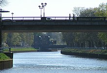
Amalienbrücke
The Amalienbrücke is a road bridge over the Hunte in Oldenburg . As with the neighboring Cäcilienbrücke , the bridge was rebuilt several times, but the name was retained.
The bridge is named after Amalie von Oldenburg .
history

Amalienbrücke was initially the name of a historic bridge over the Hunte between Poststrasse and western Amalienstraße. This bridge was demolished around 1930 after the bridge section had been piped up.
Even before 1930 , the name Amalienbrücke had been formed for the bridge at the eastern end of Amalienstraße, which led over the coastal canal (previously the Hunte-Ems Canal ). A forerunner of this bridge was built in 1893 to relieve the Cäcilienbrücke, which at that time represented the only connection between the Oldenburg city center with its newly built train station and the Osterburg district.
The Amalienbrücke 1893 was made of wood and steel , built drawbridge . As part of the construction of the coastal canal, the Amalienbrücke and the Cäcilienbrücke were demolished in 1926 and replaced by lift bridges of the same construction . Both bridges were rendered inoperable before Allied troops marched in in the spring of 1945 . The Amalienbrücke was not restored until 1950 .
With the increased frequency of motorized traffic in the course of the 1960s and 1970s , both bridges proved to be cumbersome traffic obstacles. In 1978 the construction of a new Amalienbrücke began. This was a little further downstream from the old bridge. The new Amalienbrücke was opened on June 2, 1980. The old bridge was demolished in August 1980.
The bridge
In contrast to the Cäcilienbrücke, the current Amalienbrücke is a continuous bridge. A long driveway leads the carriageway to a height of approx. 8 m above the canal and thus enables inland waterways to pass through. The entire length of the bridge is part of Amalienstraße, which extends to both banks of the Hunte. The carriageway comprises two lanes and a wide pedestrian and bicycle path on each side. From the footpaths and cycle paths, stairs can be used to reach Kanalstrasse on the left and Uferstrasse on the right bank of the river, which also crosses the Amalienbrücke.
The bridge is the last Hune bridge that crosses the river in an east-west direction.
Web links
Individual evidence
- ↑ Alt-Oldenburg, Huntestraße, pages 5ff
- ↑ Nordwest-Zeitung on October 17, 2009: 30 years ago: the city was cutting deep aisles .
Coordinates: 53 ° 8 ′ 18.8 ″ N , 8 ° 13 ′ 29.7 ″ E


