Amarkantak
| Amarkantak अमरकंटक |
||
|---|---|---|
|
|
||
| State : |
|
|
| State : | Madhya Pradesh | |
| District : | Anuppur | |
| Location : | 22 ° 41 ′ N , 81 ° 46 ′ E | |
| Height : | 1060 m | |
| Area : | 46.57 km² | |
| Residents : | 8,416 (2011) | |
| Population density : | 181 people / km² | |
| Postal code : | 484886 | |
| Website : | Amarkantak | |
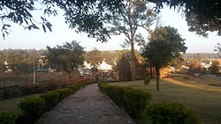
| Amarkantak - the townscape | ||
Amarkantak ( Hindi : अमरकंटक ) is a small town in the east of the Indian state of Madhya Pradesh, right on the border with the state of Chhattisgarh . The city is considered sacred by many Hindus .
Location and climate
Amarkantak is located at an altitude of approx. 1060 m in the Maikal mountain range, which connects the Vindhya and Satpura mountains in the east of Madhya Pradesh . The holy river Narmada rises here and the source of the Son , a tributary of the Ganges, is only a few kilometers away. The distance to Bhopal , the capital of Madhya Pradesh to the west, is a good 525 km (driving distance); to Prayagraj in Uttar Pradesh it is approx. 400 km north. Because of the altitude, the climate is rather cool by Indian standards; Rain falls mainly in the summer monsoon season .
population
Official population statistics have only been kept and published since 1991.
| year | 1991 | 2001 | 2011 |
| Residents | - | 7,082 | 8,416 |
The majority Hindi- speaking population consists of about 95.5% Hindus ; Muslims and Jains each make up just over 1% of the population; numerically small minorities are Christians , Sikhs , Buddhists and others. As is customary in censuses in northern India, the male population is about 12% higher than the female.
economy
Agriculture plays only a minor role because of the altitude; Instead, pilgrimage tourism is more important. The city itself serves as a center for handicrafts, trade and services of all kinds. Ayurvedic sanatoriums based on medicinal plants have also developed here.
history
The place is mentioned under the name Amrakuta by the poet Kalidasa around the year 500 . In the 11th century, the Kalachuri rulers had several temples built. The British used the place and its wooded surroundings as a hill station in the 19th and early 20th centuries .
Attractions
- For most Indians, the temple complex, consisting of over 20 small temples, including the temple pond at the Narmada spring, which is revered as holy or even divine, are the most important sights in the village.
- The nearby Shri Sarvodaya Digamber Jain Temple was only built around the turn of the millennium and offers insights into the still impressive creative power of Indian artisans. The 24-ton image of Tirthankaras Adinath meditating in the lotus position is one of the largest in India.
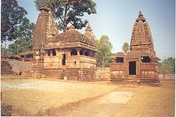
- The two architecturally and historically significant Kalachuri temples ( Machendranath and Pataleshwar ) are on the outskirts and were built in the 11th century. They each consist of a vestibule ( mandapa ) with a multi-tiered pyramid roof and the cella ( garbhagriha ) elevated by a shikhara tower with a ring stone ( amalaka ) and jug ( kalasha ).
- The Shri Yantra Temple is a 20th century building. Its roof structure in the form of a large four-faced image of a god is impressive.
Web links
- Amarkantak, history and monuments - Photos and brief information (English)
- Amarkantak, attractions - Photos and brief information (English)
- Amarkantak, history - photo + information (English)
- Amarkantak - Video (English)


