Amphoe Mueang Nong Khai
|
Amphoe Mueang Nong Khai อำเภอ เมือง หนองคาย |
|
|---|---|
| Province: | Nong Khai |
| Surface: | 607.5 km² |
| Residents: | 147,386 (2013) |
| Population density : | 238.9 U / km² |
| ZIP : | 43000, 43100 |
| Geocode : | 4301 |
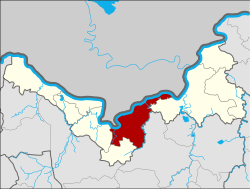
| map | |

|
|
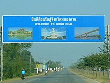
Amphoe Mueang Nong Khai ( Thai อำเภอ เมือง หนองคาย ) is a district ( Amphoe - Administrative District) in the Nong Khai Province . The province of Nong Khai is located in the northwestern part of northeast Thailand, the so-called Isan .
location
Neighboring districts (clockwise from the east): Phon Phisai district of Nong Khai province, Phen district of Udon Thani province , and Sakhrai and Tha Bo district of Nong Khai province. In the north, on the opposite bank of the Mekong River, lies the Laotian province of Vientiane (prefecture) .
Attractions
- Wat Phrathat Bang Phuan - Buddhist temple ( Wat ) with an ancient chedi , which was restored in the 16th century by King Sai Setthathirath I of the Kingdom of Lan Xang .
- Sala Kaeo Ku - Park with imaginative concrete statues of the mystic Bunleua Sulilat.
education
A sub-campus of Khon Kaen University is located in the Mueang Nong Khai district .
administration
Provincial Administration
Mueang Nong Khai County is divided into 16 tambon ("subdistricts" or "parishes"), which are further subdivided into 181 muban ("villages").
| No. | Surname | Thai | Muban | Pop. |
|---|---|---|---|---|
| 1. | Nai Mueang | ใน เมือง | - | 18,182 |
| 2. | Mi Chai | มี ชัย | 9 | 6,602 |
| 3. | Pho Chai | โพธิ์ชัย | 12 | 15,801 |
| 4th | Kuan Wan | กวน วัน | 7th | 5,374 |
| 5. | Wiang Khuk | เวียง คุก | 8th | 6.127 |
| 6th | Wat That | วัด ธาตุ | 14th | 9,703 |
| 7th | Has Kham | หาด คำ | 13 | 16,852 |
| 8th. | Hin Ngom | หิน โง ม | 8th | 4.154 |
| 9. | Ban Duea | บ้าน เดื่อ | 16 | 7,338 |
| 10. | Khai Bok Wan | ค่าย บก หวาน | 16 | 14,329 |
| 11. | Phon Sawang | โพน สว่าง | 10 | 6,196 |
| 13. | Phra That Bang Phuan | พระ ธาตุ บัง พ วน | 14th | 11,039 |
| 16. | Nong Kom Ko | หนอง ก อม เกาะ | 11 | 11,556 |
| 17th | Pa Kho | ปะ โค | 7th | 6,029 |
| 18th | Mueang Mi | เมือง หมี | 7th | 4,517 |
| 19th | Si Kai | สี กาย | 8th | 3,587 |
Note: Some of the Muban's data are not yet available.
Local administration
There is one commune with "city" status ( Thesaban Mueang ) in the district:
- Nong Khai (Thai: เทศบาล เมือง หนองคาย ) includes the entire tambon Nai Mueang, Michai and parts of the tambon Pho Chai, Khun Wan, Hat Kham, Nong Kom Ko and Mueang Mi.
There are eight municipalities with "small town" status ( Thesaban Tambon ) in the district:
- Kuan Wan (Thai: เทศบาล ตำบล กวน วัน ) consists of the parts of the Tambon Kuan Wan that do not belong to the city of Nong Khai.
- Wat That (Thai: เทศบาล ตำบล วัด ธาตุ ) consists of the entire tambon Wat That.
- Ban Duea (Thai: เทศบาล ตำบล บ้าน เดื่อ ) consists of the entire tambon Ban Duea.
- Pa Kho (Thai: เทศบาล ตำบล ปะ โค ) consists of the entire tambon Pa Kho.
- Wiang Khuk (Thai: เทศบาล ตำบล เวียง คุก ) consists of the entire tambon Wiang Khuk.
- Nong Song Hong (Thai: เทศบาล ตำบล หนองสองห้อง ) consists of parts of the Tambon Khai Bok Wan.
- Hat Kham (Thai: เทศบาล ตำบล หาด คำ ) consists of the parts of the Tambon Hat Kham that do not belong to the city of Nong Khai.
- Pho Chai (Thai: เทศบาล ตำบล โพธิ์ชัย ) consists of the parts of the Tambon Pho Chai that do not belong to the city of Nong Khai.
There are also seven " Tambon Administrative Organizations " ( องค์การ บริหาร ส่วน ตำบล - Tambon Administrative Organizations, TAO):
- Hin Ngom (Thai: องค์การ บริหาร ส่วน ตำบล หิน โง ม )
- Khai Bok Wan (Thai: องค์การ บริหาร ส่วน ตำบล ค่าย บก หวาน )
- Phon Sawang (Thai: องค์การ บริหาร ส่วน ตำบล โพน สว่าง )
- Phra That Bang Phuan (Thai: องค์การ บริหาร ส่วน ตำบล พระ ธาตุ บัง พ วน )
- Nong Kom Ko (Thai: องค์การ บริหาร ส่วน ตำบล หนอง ก อม เกาะ )
- Mueang Mi (Thai: องค์การ บริหาร ส่วน ตำบล เมือง หมี )
- Si Kai (Thai: องค์การ บริหาร ส่วน ตำบล สี กาย )
Individual evidence
- ↑ 2013 population statistics ( Thai ) Department of Provincial Administration. Retrieved August 3, 2014.
Web links
Coordinates: 17 ° 53 ' N , 102 ° 45' E

