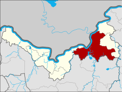
Phon Phisai district
|
Phon Phisai โพนพิสัย |
|
|---|---|
| Province: | Nong Khai |
| Surface: | 642.7 km² |
| Residents: | 97,835 (2013) |
| Population density : | 149.1 U / km² |
| ZIP : | 43120 |
| Geocode : | 4305 |
| map | |

|
|
Amphoe Phon Phisai ( Thai : อำเภอ โพนพิสัย ) is a district ( Amphoe - administrative district) in Nong Khai Province . The province of Nong Khai is located in the north of the northeast region of Thailand , the so-called Isan .
geography
The province of Nong Khai is located about 615 kilometers northeast of Bangkok along the Mekong , which here forms the border with Laos .
Phon phisai district borders the following counties (from the east clockwise) to the Amphoe Rattanawapi and Fao Rai in Nong Khai province, the Amphoe Ban Dung , Sang Khom and Phen of Udon Thani province , as well as Amphoe Mueang Nong Khai again in Nong Khai. To the north on the other bank of the Mekong are the Vientiane Prefecture and the Bolikhamsai Province of Laos .
history
Phon Phisai was originally part of the Mueang Phon Phaeng, which today belongs to Rattanawapi. In 1906 it was made an amphoe.
administration
Provincial Administration
Phon Phisai County is divided into eleven tambon ("subdistricts" or "communities"), which are further subdivided into 159 muban ("villages").
| No. | Surname | Thai | Muban | Pop. |
|---|---|---|---|---|
| 1. | Chumphon | จุมพล | 26th | 19,938 |
| 2. | Wat Luang | วัดหลวง | 16 | 9,285 |
| 3. | Kut bong | กุด บ ง | 14th | 8,686 |
| 4th | Chum Chang | ชุม ช้าง | 19th | 9,663 |
| 6th | Thung Luang | ทุ่ง หลวง | 12 | 5,283 |
| 7th | Lao Tang Kham | เหล่า ต่าง คำ | 15th | 6,511 |
| 8th. | Well nang | นา หนัง | 17th | 11,289 |
| 9. | OEM | เซิ ม | 11 | 7,627 |
| 13. | Ban Pho | บ้านโพธิ์ | 13 | 10,275 |
| 21st | Ban Phue | บ้าน ผื อ | 8th | 5,621 |
| 22nd | Sang Nang Khao | สร้าง นาง ขาว | 8th | 3,657 |
Note: The missing numbers (geocodes) refer to the tambon , which today belong to Fao Rai and Rattanawapi.
Local administration
There are two municipalities with "small town" status ( Thesaban Tambon ) in the district:
- Sang Nang Khao (Thai: เทศบาล ตำบล สร้าง นาง ขาว ), consisting of the entire Tambon Sang Nang Khao.
- Phon Phisai (Thai: เทศบาล ตำบล โพนพิสัย ), consisting of parts of the Tambon Chumphon.
There are also ten " Tambon Administrative Organizations " ( องค์การ บริหาร ส่วน ตำบล - Tambon Administrative Organizations, TAO):
- Chumphon (Thai: องค์การ บริหาร ส่วน ตำบล จุมพล )
- Wat Luang (Thai: องค์การ บริหาร ส่วน ตำบล วัดหลวง )
- Kut Bong (Thai: องค์การ บริหาร ส่วน ตำบล กุด บ ง )
- Chum Chang (Thai: องค์การ บริหาร ส่วน ตำบล ชุม ช้าง )
- Thung Luang (Thai: องค์การ บริหาร ส่วน ตำบล ทุ่ง หลวง )
- Lao Tang Kham (Thai: องค์การ บริหาร ส่วน ตำบล เหล่า ต่าง คำ )
- Na Nang (Thai: องค์การ บริหาร ส่วน ตำบล นา หนัง )
- OEM (Thai: องค์การ บริหาร ส่วน ตำบล เซิ ม )
- Ban Pho (Thai: องค์การ บริหาร ส่วน ตำบล บ้านโพธิ์ )
- Ban Phue (Thai: องค์การ บริหาร ส่วน ตำบล บ้าน ผื อ )
Individual evidence
- ↑ 2013 population statistics ( Thai ) Department of Provincial Administration. Retrieved August 3, 2014.
Web links
Coordinates: 18 ° 1 ' N , 103 ° 5' E
