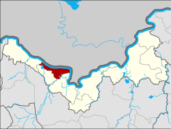
Si Chiang Mai district
|
Si Chiang Mai ศรีเชียงใหม่ |
|
|---|---|
| Province: | Nong Khai |
| Surface: | 198.0 km² |
| Residents: | 30,691 (2013) |
| Population density : | 157.2 U / km² |
| ZIP : | 43130 |
| Geocode : | 4307 |
| map | |

|
|
Amphoe Si Chiang Mai ( Thai : อำเภอ ศรีเชียงใหม่ ) is a district ( Amphoe - administrative district) in the west of Nong Khai Province . The province of Nong Khai is located in the north of the northeast region of Thailand , the so-called Isan .
geography
The province of Nong Khai is located about 615 kilometers northeast of Bangkok along the Mekong , which here forms the border with Laos .
Amphoe Si Chiang Mai is bordered by the following counties (clockwise from southeast): Amphoe Tha Bo , Pho Tak and Sangkhom in Nong Khai Province. To the north on the other bank of the Mekong lies the Vientiane Prefecture of Laos .
history
Si Chiang Mai is an ancient city that was founded by King Sai Setthathirath I of the Lan Xang Kingdom . Its name is said to remind of Mueang Chiang Mai , the home of his princess.
Amphoe Si Chiang Mai was established as a county of Nong Khai Province on August 4, 1958, when its area was separated from Amphoe Tha Bo .
Attractions
- Wat Hin Mak Peng - Buddhist temple ( wat ) on the banks of the Mekong
administration
Provincial Administration
Si Chiang Mai County is divided into four tambon ("subdistricts" or "parishes"), which are further subdivided into 43 muban ("villages").
| No. | Surname | Thai | Muban | Pop. |
|---|---|---|---|---|
| 1. | Phan Phrao | พาน พร้าว | 15th | 13,513 |
| 3. | Ban Mo | บ้านหม้อ | 8th | 4,346 |
| 4th | Phra Phutthabat | พระพุทธบาท | 10 | 4,991 |
| 5. | Nong Pla Pak | หนอง ปลาปาก | 10 | 7,841 |
Note: The missing numbers (geocodes) refer to the tambon that belong to Pho Tak today.
Local administration
There are two municipalities with "small town" status ( Thesaban Tambon ) in the district:
- Nong Pla Pak (Thai: เทศบาล ตำบล หนอง ปลาปาก ), consisting of the entire tambon Nong Pla Pak.
- Si Chiang Mai (Thai: เทศบาล ตำบล ศรีเชียงใหม่ ), consisting of parts of the Tambon Phan Phrao.
There are also three " Tambon Administrative Organizations " ( องค์การ บริหาร ส่วน ตำบล - Tambon Administrative Organizations, TAO):
- Phan Phrao (Thai: องค์การ บริหาร ส่วน ตำบล พาน พร้าว )
- Ban Mo (Thai: องค์การ บริหาร ส่วน ตำบล บ้านหม้อ )
- Phra Phutthabat (Thai: องค์การ บริหาร ส่วน ตำบล พระพุทธบาท )
Individual evidence
- ↑ 2013 population statistics ( Thai ) Department of Provincial Administration. Retrieved August 3, 2014.
Web links
Coordinates: 17 ° 57 ' N , 102 ° 35' E
