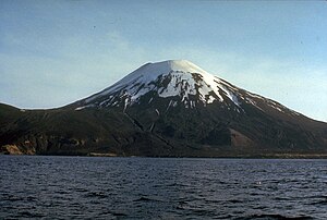
Amukta Island
| Amukta | ||
|---|---|---|
| height | 1066 m | |
| location | Aleutian Islands , USA | |
| Coordinates | 52 ° 30 ′ 0 ″ N , 171 ° 15 ′ 8 ″ W | |
|
|
||
| Type | Stratovolcano | |
| Last eruption | 1997 | |
Located in the central Aleutian Islands , southwest of Chagulak Island, Amukta Island is the westernmost of the Islands of Four Mountains . It is used by the symmetric Stratovolcano formed Amukta having a diameter of 7.7 kilometers. The volcano has a crater with a diameter of 400 meters. There is a cinder cone on the northwest coast .
Well-documented reports of early volcano activity are sparse. Historical records show an explosive eruption phase from June 1786 to 1791, during which several million cubic meters of tephra were ejected, and an eruption in 1878. During the eruption on February 13, 1963, both ash and lava were ejected from the central crater and side cones. The observation conditions were very poor due to fog, but the lava flow could be observed when it reached the sea from the west side of the crater at Traders Cove. In late August and early September 1987, a pilot of a traffic plane observed a 10.5 kilometer high ash cloud over Amukta Island. Additional reports from pilots about ash clouds followed on September 4 and September 18, 1987. In early July 1996 a ship reported a 1 kilometer high cloud of ash and smoke and on March 3, 1997 an explosive eruption occurred in the central crater of the volcano.
Web links
- Amukta Island in the Global Volcanism Program of the Smithsonian Institution (English)
- Alaska volcano observatory (English)
- Amukta Island in the Geographic Names Information System of the United States Geological Survey

