Andover (Kansas)
| Andover | |
|---|---|
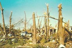
 Tornado damage 1991 |
|
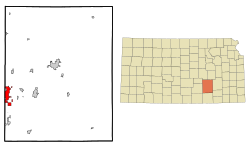
| Location in Kansas | |
| Basic data | |
| Foundation : | 1873 |
| State : | United States |
| State : | Kansas |
| County : | Butler County |
| Coordinates : | 37 ° 41 ′ N , 97 ° 8 ′ W |
| Time zone : | Central ( UTC − 6 / −5 ) |
| Residents : | 11,791 (as of 2010) |
| Population density : | 666.2 inhabitants per km 2 |
| Area : | 17.8 km 2 (approx. 7 mi 2 ) of which 17.7 km 2 (approx. 7 mi 2 ) are land |
| Height : | 412 m |
| Postal code : | 67002 |
| Area code : | +1 316 |
| FIPS : | 20-01800 |
| GNIS ID : | 0474204 |
| Website : | www.andoverks.com |
Andover is a small town in the US state of Kansas in Butler County with 11,791 inhabitants (as of 2010). Andover is in close proximity to Wichita , the largest city in the state.
history
Andover was founded in February 1869 under the name Minneha and received its current name on June 7, 1880. The most important event in the city for the next hundred years was a train robbery in July 1898.
On April 26, 1991, an F5 tornado destroyed a third of the city. The cyclone known as the Andover Outbreak is counted among the 50 worst in US history.
population
With 11,791 (as of 2010), the city ranks 31st in the list of the most populous cities in Kansas .
Over 95% of the population are white, 6.3% of the population lived below the poverty line in 2000 , the proportion of people over 65 was significantly higher at 11.6%.
Sons and Daughters of Andover
- Kevin Schmidt (* 1988), actor
Web links
- Official website of the city of Andover ( English )
Individual evidence
- ^ Andover in the Geographic Names Information System of the United States Geological Survey , accessed April 6, 2015
