Angerbach (Ammer)
|
Angerbach upper course: Ramseer Bach in Weilheim: Stadtbach |
||
|
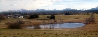
Spring pond of the Ramseer Bach |
||
| Data | ||
| Water code | DE : 164312 | |
| location | Bavaria , Weilheim-Schongau district | |
| River system | Danube | |
| Drain over | Ammer → Isar → Danube → Black Sea | |
| source | at Obersöchering 47 ° 44 ′ 46 ″ N , 11 ° 13 ′ 8 ″ E |
|
| Source height | 664 m above sea level NHN | |
| muzzle | near Weilheim
|
|
| length | 15.4 km | |
| Catchment area | 34.83 km² | |
| Right tributaries | Weidenbach | |
The Angerbach , on the upper reaches of the Ramseer Bach , called Stadtbach in Weilheim , is a right tributary of the Ammer in the Upper Bavarian district of Weilheim-Schongau .
geography
The Angerbach rises as the Ramseer Bach near Obersöchering in a nameless spring pond at the Eckenbichelsee . It flows consistently in a northerly to westerly direction and initially runs north through the Amettal . In Eberfing , where it is already known as Angerbach, it takes the Weidenbach from the right. In Deutenhausen the brook is divided to operate a mill and reunited after about a kilometer. Shortly before Weilheim in Upper Bavaria the brook divides again, the right main branch feeds the Zotzenmühle . In Weilheim it is called Stadtbach and is partially canalized. At the bridge over this river in the city, the Angerbach finally flows into the Ammer from the right .
Individual evidence
Web links
- Run of the Angerbach on the BayernAtlas
