
Spiekeroog pier

Since 1891 there have been four different jetties , one after the other, on the East Frisian island of Spiekeroog , via which ferry traffic between the mainland and the island was handled. They were always rebuilt in the same place on the southern tip of the island after being destroyed or worn out by storm surge or ice drift . The Spiekeroog island railway ran from the pier to the island village of Spiekeroog. Since 1981 there has been a local port south of the village, so that the island railway and pier are no longer necessary and have been abandoned.
Time before investors

Before 1891 there was no pier in Spiekeroog. Ships going to the island had nowhere to dock. Therefore, when the water ran off, they let themselves dry near the beach . The passengers had to walk the last few meters through the remaining water or silt; later horse-drawn carts were used to bring passengers and goods through the mudflats or shallow water from ship to land.
First investor 1891–1926

In 1891 the first pier was opened in the very south of the island, built from the cargo of a stranded timber freighter. For the connection to the village, a branch and a new route through the salt marshes to the pier was created from the existing horse-drawn tram . In the area of the jetty, the track was laid on the mud flats and flooded during high water. The tracks running on the pier were only used by a baggage cart, while the passengers only boarded the horse-drawn tram after the pier.
Second investor 1926–1949

In 1927 a new pier was built after the old one was destroyed by ice in the winter of 1926. The track still ran on the mud flats.
Third investor 1949–1969

To the west of the previous jetty, a new jetty was built in 1949 so that ferry boats could dock directly at it and the train could drive over a Pfahljoch route to the jetty. After 1969 it was no longer used, but remained as an icebreaker. The remains of it could still be seen after 2009.
Fourth investor 1962–2009

After the great storm surge of 16./17. In February 1962 the WSA built a new jetty next to the previous one in order to be able to handle the extensive transport of materials for the fastening work. This pier was 70 centimeters higher than the existing one and was 70 meters further in the water. Therefore a second pile yoke section had to be built. From 1965 the island railway was allowed to use it for passenger traffic, and from 1968 also for freight traffic. The third pier remained as an icebreaker, but was no longer used as a pier. The new pier continued to belong to the WSA, while the island railway was responsible for maintenance. Between 1967 and 1981, the Spiekeroog III ferry, which was in operation until 2012, also docked at the pier.
The entire structure of the last pier was at times around 300 meters long and up to 20 meters wide. It consisted of a track on wooden supports over the beach and a jetty that protruded into the sea during high tide and was accessible by rail vehicles. The feed track forked into four tracks on the pier, three of which were brought together again at the end of the pier to enable shunting work. The fourth track ended at a ramp so that it was possible to load larger goods and vehicles onto a wagon without the help of a crane. The jetty had a total of six points.
After the closure as the main pier on the island
From 1981 the pier was only occasionally used by sport boats , but this became more and more difficult due to the increasing siltation of the harbor basin. With each storm surge, the pier was more damaged. It was foreseeable that the water would eventually destroy the pier completely. Entry was forbidden, parts of an earlier fence were still there for a long time. The jetty was a popular destination for tourists and islanders alike. In April 2007, however, the municipality of Spiekeroog decided to demolish it after 26 years and then carried it out from August 2009. End of September 2009, the dismantling of the investor was already completed, now only exists in its place during the demolition of the investor newly built breakwater .
Designation "old investor"
The jetty at the western end of the island, which was unused between 1981 and 2009, was called the old jetty by islanders and tourists . The name became established and became an institution on the island, so it was said, for example, "go to the old pier".
Spiekeroog Harbor 1981 – today
In 1981 the Spiekerooger Hafen was completed; with its commissioning, the island railway was given up. It is located about 500 meters south of the island village. In order to make the port accessible for shipping, an approximately one nautical mile long fairway was dredged through the mudflats. However, the port can only be reached by ferry depending on the tide .
Aftermath
After the entire island railway and the jetty were in need of overhaul at the end of the 1970s, the construction of a nearby port was started in 1979, from which passengers could get to the place without using the island railway. The port was built with a two-kilometer fairway and a harbor basin before the Wadden Sea became a national park in 1986 and a UNESCO World Heritage Site in 2009 .
While the island railway on Spiekeroog was abandoned, the island railway on Wangerooge and Langeoog are now part of the island's flair.
Gallery of the remains of the fourth, "Old Investor" (2006)

Track remains with a buffer stop

Track remains of the feeder track

Feeder track of the former Pfahljoch route to the pier with Langeoog in the background

Former shunting area of the investor
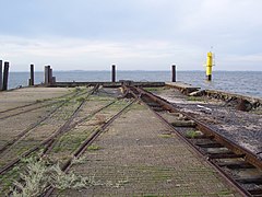
Fourth investor (1962 to 2009), known as the "old investor" after it was closed in 1981


literature
- Malte Werning: island railways of the North Sea . GeraMond, Munich 2003, ISBN 3-7654-7245-X .
- Egbert Nolte: The Spiekerooger Inselbahn . Branch line documentation 64, Kenning, Nordhorn 2000, ISBN 3-933613-23-X .
- Hans Wolfgang Rogl: The North Sea Island Railways . 6th edition, alba, Düsseldorf 1996, ISBN 3-87094-230-4 .
- Die Kleinbahn, trade journal for secondary + narrow-gauge railways , No. 78 from August 1, 1975.
Web links
- Inselbahn.de - The Spiekerooger Inselbahn - with photos and vehicle list
- Old Spiekeroog investor - website with photos of the Spiekeroog investor shortly before the demolition
Individual evidence
- ^ History on the website of inselbahn.de, accessed on September 6, 2012.
- ↑ National Park on the website of the Wadden Sea National Park.
- ↑ Weltnaturerber on the website of the Wadden Sea National Park.
Coordinates: 53 ° 45 ′ 0.7 " N , 7 ° 40 ′ 56.7" E