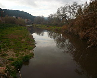
Anoia (river)
| Anoia | ||
|
Anoia at Martorell's |
||
| Data | ||
| location | Catalonia , Spain | |
| River system | Llobregat | |
| Drain over | Llobregat → Mediterranean | |
| Source height | 800 msnm | |
| muzzle | at Martorell in Llobregat coordinates: 41 ° 28 ′ 43 " N , 1 ° 56 ′ 6" E 41 ° 28 ′ 43 " N , 1 ° 56 ′ 6" E |
|
| Mouth height | 56 msnm | |
| Height difference | 744 m | |
| Bottom slope | 12 ‰ | |
| length | 64 km | |
| Catchment area | 929 km² | |
Anoia is a small tributary of the Llobregat in Catalonia ( Spain ). The exact location of its source is not known. At Jorba (400 m) 4 source rivers Copons, Clariana, Rubió, and Tous join to the Rio Anoia, it flows into the Llobregat at Martorell .
River course
The headwaters are located at an altitude of 600 to 800 m between the towns of Calaf and Molí de la Roda, Veciana, la Panadella and Clariana, in the geological formation of the Oligocene with its limestone and gypsum-containing sedimentary rocks . The catchment area of the river covers 930 km² and is located in the Comarcas Anoia , the north of Solsonès , Bages and the south of Alt Penedès . The Anoia flows in a south-easterly direction, at Sant Sadurní d'Anoia it makes an arc of 90 degrees and then flows in a north-easterly direction until it pours into the Rio Llobregat after 65 km, overcoming a gradient of 700 m.
There are 8 sewage treatment plants on the banks of the river and a paper industry at Capellades .
Tributaries
- Bitlles
- l'Avern
- Hortons
- Carme
Places / cities
- Jorba (400 m)
- Igualada (285 m)
- Vilanova del Camí
- La Pobla de Claramunt (245 m)
- Capellades (317 m)
- Vallbona d'Anoia
- Sant Sadurní d'Anoia (161 m)
- Gelida
- Martorell (56 m)
