Aperer Freiger
| Aperer Freiger | ||
|---|---|---|
|
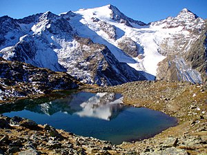
View from the Upper Grünausee to the Wilder Freiger (middle, upper edge of the picture), to the right of it the Lübecker Scharte and on the upper right of the picture, the east face of the Aperen Freiger |
||
| height | 3261 m above sea level A. | |
| location | Tyrol , Austria | |
| Mountains | Stubai Alps | |
| Dominance | 0.9 km → Wilder Freiger | |
| Notch height | 115 m ↓ Lübecker Scharte | |
| Coordinates | 46 ° 58 '36 " N , 11 ° 10' 46" E | |
|
|
||
| Type | Rock peaks | |
| First ascent | 1863 by Leopold Pfaundler von Hadermur and Ludwig von Barth with the mountain guide Alois Tanzer | |
| Normal way | Mountain tour from the Sulzenauhütte over the Lübecker Weg , finally over the west ridge in easy block climbing ( UIAA I ) | |
The Apere Freiger is a 3261 m above sea level. A. high mountain in the Stubai Alps in Tyrol , Austria .
rise
The ascent takes place as a mountain tour in about 3.5 hours walking time from the Sulzenauhütte over the Lübecker Weg , finally over the west ridge in easy block climbing ( UIAA I ) to the summit.
Literature and map
- Heinrich and Walter Klier : Alpine Club Guide Stubai Alps. Bergverlag Rudolf Rother, Munich 2006, ISBN 3-7633-1271-4 .
- Alpine Club Card. Sheet 31/1, 1: 25,000, Stubai Alps; Hochstubai. ISBN 978-3-928777-07-0 .
Web links
- Aperer Freiger from the Sulzenauhütte. Retrieved July 16, 2013 .

