
Araguaçu
| Município de Araguaçu "A capital do gado branco"
Araguaçu
|
|||
|---|---|---|---|
|
|||
| Coordinates | 12 ° 56 ′ S , 49 ° 50 ′ W | ||
 Location of Araguaçu in the state of Tocantins Location of Araguaçu in the state of Tocantins
|
|||
| founding | November 14, 1958 | ||
| Basic data | |||
| Country | Brazil | ||
| State | Tocantins | ||
| ISO 3166-2 | BR-TO | ||
| Mesoregion | Ocidental do Tocantins (1989-2017) | ||
| Microregion | Rio Formoso (1989-2017) | ||
| structure | 1 multiple district | ||
| height | 278 m | ||
| climate | Aw, tropical | ||
| surface | 5,187.5 km² | ||
| Residents | 8786 (2010) | ||
| density | 1.7 Ew. / km² | ||
| estimate | 8517 Ew. (July 1, 2019) | ||
| Parish code | IBGE : 1702000 | ||
| Time zone | UTC −3 | ||
| politics | |||
| City Prefect | Joaquim Pereira Nunes (2017-2020) | ||
| Political party | PRB | ||
| economy | |||
| GDP | 157,989 thousand. R $ 18,000 R $ per capita (2015) |
||
| HDI | 0.675 (2010) | ||

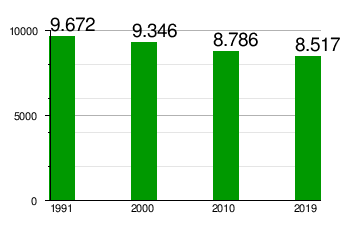
Araguaçu , officially Município de Araguaçu , is a city founded in 1958 in the Brazilian state of Tocantins in the Região Norte . It is 413 km from the capital of Palma . The population was estimated on July 1, 2019 at 8,517 inhabitants, called Araguaçuenses (Portuguese araguaçuenses ), who live in an area of around 5187 km². The population density is 1.7 people per km². The population has been declining over the past 20 years.
geography
The municipality is influenced by the Rio Araguaia and Rio Formoso rivers .
The landscape and climate are those of the Brazilian Cerrado . There is a tropical savanna climate, according to the Köppen and Geiger Aw climate classification . The height above sea level is 278 meters.
Surrounding towns are:
| Northwest: | North: Figueirópolis , Sandolândia , Alvorada | Northeast: |
| West: State of Goiás |

|
East: Alvorada , Talismã , Goiás State |
| Southwest: | South: State of Goiás | Southeast: |
history
The place was founded on November 14, 1958 in Goiás. When Tocantins was founded, it came to the new state on January 1, 1989 by splitting off from Goiás.
City administration
Executive: In the local elections in 2016, Joaquim Pereira Nunes was elected city prefect (mayor) for the 2017-2020 term. He is a member of the Partido Republicano Brasileiro (PRB).
The legislature rests with a nine-member city council, the vereadores of the Câmara Municipal, the 2017/2018 presidency lies with Sebastião Sabino de Souza, who is a member of the PSB.
Population development
Source: IBGE (figures for 2019 are only estimates). In 2010, 24.39% of the population were children and adolescents up to the age of 15. In 2010, 66.95% lived in urban areas and 33.05% in extensive rural areas.
Standard of living
The human development index for cities, abbreviated HDI (Portuguese: IDH-M ), was at the low value of 0.332 in 1991 and at the medium high value of 0.675 in 2010.
literature
- Secretaria do Planejamento e Orçament (SEPLAN): Araguaçu 2017 . Ed .: Governo do Estado do Tocantins (= Perfil Socioeconômico dos Municípios ). Palmas 2017 (Brazilian Portuguese, online [PDF]).
Web links
- City Council website , Câmara Municipal (Brazilian Portuguese)
Individual evidence
- ↑ a b c d Instituto Brasileiro de Geografia e Estatística (IBGE): Tocantins: Araguaçu - Panorama. Retrieved September 8, 2019 (Brazilian Portuguese).
- ↑ Kinca Nunes 10. In: com.br. Eleições 2016, accessed January 22, 2018 (Brazilian Portuguese).
- ↑ Mesa Diretora. In: leg.br. Câmara de Araguaçu, accessed January 22, 2018 (Brazilian Portuguese).
- ↑ a b Atlas do Desenvolvimento Humano do Brasil: Araguaçu. Retrieved January 22, 2018 (English, Portuguese).