Arizona State Route 101

|
|
|---|---|
| map | |

|
|
| Basic data | |
| Overall length: | 61 mi / 98 km |
| Opening: | 1988 |
| Starting point: |
|
| End point: |
|
| County: | Maricopa County |
| Important city: | Phoenix |
The Arizona State Route 101 (short- AZ 101 ) is a state highway in the US state of Arizona .
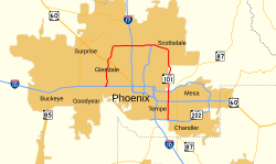
The State Route begins on Interstate 10 in Tolleson and ends 98 kilometers in Chandler on Arizona State Route 202 . It forms half a motorway ring in the greater Phoenix area and connects some suburbs such as Glendale , Scottsdale and Mesa .
course
Aqua Fria Freeway
The first section of Arizona State Route 101, also known as the Aqua Fria Freeway , begins in Tolleson on Interstate 10. It initially runs north, passing the University of Phoenix Stadium and the Jobing.com Arena . In Peoria AZ 101 meets the US Highway 60 . After passing the Peoria Sports Complex and Arrowhead Towne Center , it continues east. After 37 kilometers, the Aqua Fria Freeway ends at Interstate 17 and merges into the Pima Freeway .
Pima Freeway
After the junction with I-17, AZ 101 leads south of Phoenix Deer Valley Airport in an easterly direction through the foothills of the Union Hills. From the intersection with Arizona State Route 51 , the Piestewa Freeway , it runs in a south-easterly direction, and from Scottsdale in a southerly direction. She passes downtown Scottsdale and Scottsdale Community College . After crossing the Salt River, the road crosses Arizona State Route 202 and becomes the Price Freeway .
So-called HOV lanes are currently being built between Scottsdale and AZ 202 . A first section connecting the Via de Ventura exit to the intersection of State Route 202 opened in early November.
Price Freeway
The final section of Arizona State Route 101 connects the Red Mountain Freeway with the Santan Freeway, both of which are part of AZ 202. The State Route passes Arizona State University and crosses US Highway 60 again at the city limits of Tempe. After the cross, the State Route reaches the city of Chandler and ends after 98 kilometers at the Santan Freeway.
See also
Individual evidence
- ↑ Arizona Department of Transportation: New HOV lanes to greet commuters on Loop 101 Monday morning ( Memento of November 13, 2008 in the Internet Archive )
Web links
- Arizona Roads (English)