Arroyo de las Víboras (Río Uruguay)
| Arroyo de las Víboras | ||
|
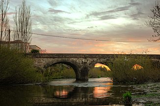
The Puente Castells over the Arroyo de las Víboras |
||
| Data | ||
| location | South America , Uruguay | |
| River system | Río de la Plata | |
| Drain over | Uruguay → La Plata → Atlantic | |
| source | Cuchilla de San Salvador | |
| Source height | 100 m | |
| muzzle |
Río Uruguay Coordinates: 33 ° 57 ′ 5 " S , 58 ° 21 ′ 58" W 33 ° 57 ′ 5 " S , 58 ° 21 ′ 58" W
|
|
| Left tributaries | de la Tahona | |
| Right tributaries | Sauce, Sauce, NN, Arroyo Chileno , Arroyo de las Flores , Arroyo Polancos | |
The Arroyo de las Víboras is a river located in the area of the Colonia Department in southwest Uruguay .
The left tributary of the Río Uruguay , into which it flows east-west, rises in the Cuchilla de San Salvador at an altitude of about 100 meters above sea level. The estuary is opposite the Isla Juncal island in the Uruguayan River . Right-hand tributaries of the Arroyo de las Viboras are the Arroyo Chileno , the Arroyo de las Flores and the Arroyo Polancos . On the left side of the river it is fed by several small streams. Its banks are lined with forest. On its lower course, which runs through floodplains, there is vegetation typical of wetlands. Its last section up to the mouth is canalized. There it leads near its confluence with the Río Uruguay under the Ruta 21 and a narrow stone bridge built there in 1858 by Jaime Castells.
Individual evidence
- ↑ Information on the website of the natural science faculty of the Universidad de la República .
- ↑ http://www.ine.gub.uy/mapas/departamental/a0h_colonia.pdf Map showing the course of the river on the website of the Instituto Nacional de Estadística de Uruguay
