Ashford, Alabama
| Ashford | |
|---|---|
|
Location in Alabama
|
|
| Basic data | |
| State : | United States |
| State : | Alabama |
| County : | Houston County |
| Coordinates : | 31 ° 11 ′ N , 85 ° 14 ′ W |
| Time zone : | Central ( UTC − 6 / −5 ) |
| Residents : | 2,148 (as of 2010) |
| Population density : | 135.9 inhabitants per km 2 |
| Area : | 15.8 km 2 (about 6 mi 2 ) of which 15.8 km 2 (about 6 mi 2 ) is land |
| Height : | 85 m |
| Postal code : | 36312 |
| Area code : | +1 334 |
| FIPS : | 01-02836 |
| GNIS ID : | 0113251 |
| Website : | www.cityofashford.com |
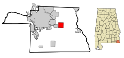
Ashford is a place in Houston County in the US state of Alabama .
geography
Ashford is located in southeast Alabama in the southern United States. The location is about 18 kilometers from the southern Florida border and 10 kilometers from the eastern Georgia border.
Nearby locations include Avon (1 km west), Cowarts (2 km west), Webb (4 km north), Dothan (6 km west), and Gordon (9 km southeast).
history
The place was founded in 1891. In the early years of its existence, turpentine oil production and agriculture were the main economic drivers in Ashford. The production of turpentine oil became insignificant for the place due to the spread of petroleum at the beginning of the 20th century and the cultivation of cotton and peanuts became the primary source of income, with the cultivation of cotton being largely displaced again towards the end of the 20th century.
A structure in Ashford is listed on the National Register of Historic Places (NRHP) as of March 20, 2020, the Alabama Midland Railway Depot .
traffic
In the south of the city runs the US Highway 84 , which runs over 3,088 kilometers from Colorado through seven states to Georgia. In nearby Dothan there is also a connection to Alabama State Route 1 and US Highway 431 .
Dothan Regional Airport is located around 20 kilometers to the north-west and handles around 85,000 aircraft movements annually. Scheduled flights are only offered to Hartsfield – Jackson Atlanta International Airport .
Demographics
At the 2000 census, Ashford had 1,853 residents, distributed among 763 households and 527 families. The population density was thus 117.3 inhabitants / km². 71.45% of the population were white. 27.52% African American. Children under the age of 18 lived in 30.1% of households. The median income was $ 29,444 per household, with 16.9% of the population living below the poverty line .
Web links
- Official website (English).
- Statistical data on Ashford (Engl.)
Individual evidence
- ↑ Missouri Census Data Center ( page no longer available , search in web archives ) Info: The link was automatically marked as defective. Please check the link according to the instructions and then remove this notice. Retrieved October 12, 2012
- ↑ About Ashford. Town of Ashford, accessed June 11, 2009 .
-
↑ Search mask database in the National Register Information System. National Park Service , accessed March 20, 2020.
Weekly List on the National Register Information System. National Park Service , accessed March 20, 2020. - ↑ Website of the US Census Bureau (English)
