Louse
| province |
|
| local community |
|
|
Area - land - water |
0.92 km 2 0.88 km 2 0.04 km 2 |
| Residents | 170 (Jan. 1, 2018) |
| Coordinates | 51 ° 14 ′ N , 6 ° 1 ′ E |
| Important traffic route |
|
| prefix | 0475 |
| Postcodes | 6071 |
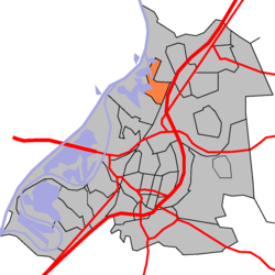
| Location of Asselt in the municipality of Roermond | |
Asselt is a village of around 170 inhabitants (as of January 1, 2018) in the municipality of Roermond , Limburg province ( Netherlands ).
location
Asselt is located on the Meuse and on the so-called Maasplassen (Maas lakes) that were created by excavating gravel .
history
In the Carolingian period (8th to 11th centuries) Asselt was a Franconian Fronhof , which also served as a palace .
In 881 Vikings ( Normans ) set up a camp here, from where they undertook numerous raids into the wider area, such as B. in the Rhine area and in the Weser area.
The Roman Catholic Church of Saint Dionisius was built in the 11th century.
Until 2007, Asselt was part of what was then the municipality of Swalmen .
Individual evidence
- ↑ a b Kerncijfers wijken en buurten 2018 . In: StatLine . Centraal Bureau voor de Statistiek , February 1, 2019, accessed on March 13, 2019 (Dutch)
- ↑ Annales Fuldenses - Reginonis abbatis Prumiensis Chronicon .
Web links
Commons : Asselt - collection of images, videos and audio files

