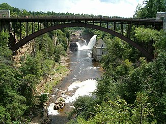
Ausable River
| Ausable River | ||
|
Ausable Chasm Bridge with Rainbow Falls in the background |
||
| Data | ||
| Water code | US : 969832 | |
| location | Clinton , Essex County in New York (USA) | |
| River system | Saint Lawrence River | |
| Drain over | Rivière Richelieu → Saint Lawrence River → Atlantic Ocean | |
| confluence | from East Branch and West Branch Ausable Rivers 44 ° 26 ′ 26 ″ N , 73 ° 40 ′ 29 ″ W |
|
| Source height | 160 m | |
| muzzle |
Lake Champlain Coordinates: 44 ° 33 ′ 22 " N , 73 ° 25 ′ 22" W 44 ° 33 ′ 22 " N , 73 ° 25 ′ 22" W |
|
| Mouth height | 29 m | |
| Height difference | 131 m | |
| Bottom slope | approx. 3.7 ‰ | |
| length | approx. 35 km | |
| Catchment area | 1340 km² | |
| Discharge at the Au Sable Forks gauge ( ⊙ ) A Eo : 1142 km²
|
MQ 1912/2012 Mq 1912/2012 HHQ (08/28/2011) |
20 m³ / s 17.5 l / (s km²) 1317 m³ / s |
| Communities | Au Sable Forks , Keeseville | |
|
Ausable chasm |
||
The Ausable River is a tributary of Lake Champlain in the US state of New York .
The Ausable River arises in the eastern Adirondack Mountains at the confluence of the two headwaters East Branch and West Branch Ausable River at Au Sable Forks . It flows mainly in an easterly direction to Lake Champlain . He passes the place Keeseville . It then flows through the sandstone gorge Ausable Chasm . Finally it flows into the west bank of Lake Champlain. The mouth of the Ausable River is in the Ausable Marsh State Wildlife Management Area . The Ausable River has a length of about 35 km. The catchment area covers 1340 km². The mean discharge is 20 m³ / s.
Hydropower plants
There are two hydropower plants on the Ausable River. They are located in the Ausable Chasm area east of Keeseville.
Hydroelectric power plants on the Ausable River downstream:
| Surname | Power in MW |
Number of turbines |
location | operator |
|---|---|---|---|---|
| Alice Falls | 2.1 | 2 | ( ⊙ ) | Alice Falls Corp. |
| Rainbow Falls | 2.6 | 2 | ( ⊙ ) | New York State Elec & Gas Corp. |

