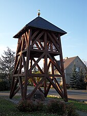
Bärenbrück
|
Bärenbrück
Barbuk Teichland municipality
Coordinates: 51 ° 48 ′ 40 ″ N , 14 ° 28 ′ 31 ″ E
|
|
|---|---|
| Height : | 65 m above sea level NN |
| Area : | 8.57 km² |
| Residents : | 252 (December 31, 2011) |
| Population density : | 29 inhabitants / km² |
| Incorporation : | December 31, 2000 |
| Postal code : | 03185 |
| Area code : | 035601 |
Bärenbrück , Barbuk in Lower Sorbian , is a village in Lower Lusatia . Since December 31, 2000, the formerly independent municipality has been the smallest of the three districts of the municipality of Teichland in the Brandenburg district of Spree-Neisse . It has 252 residents (as of 2011).
geography
The district is located around five kilometers southeast of the town of Peitz in the middle of a pond landscape that gives the municipality its name. To the north of the village is the 88 hectare under pond . In the south, from 1975 onwards, overburden from the nearby open-cast mining sites Jänschwalde and Cottbus-Nord created the Bärenbrücker Höhe , which protrudes 33 m from the landscape.
history
Bärenbrück was first mentioned in 1400 as Berenbrug . The name probably indicates the settlement of a swamp area where bears lived. The ponds, which were probably created under Margrave Hans von Küstrin between 1540 and 1545, were destroyed by Austrian troops in the Seven Years' War (1756–1763).
With effect from December 31, 2000, the municipality of Bärenbrück merged with the previously independent municipalities Mouse and Neuendorf to form the new municipality of Teichland.
Individual evidence
- ↑ according to "Information from the municipal administrations" in: Excerpt from the property market report 2011, Spree-Neisse district. Expert committee for property values, Cottbus 2012 ( PDF 300 kB), p. 13 in PDF
- ^ StBA: Changes in the municipalities in Germany, see 2000
Web links
- History from Bärenbrück at the Peitz office

