Bürstel (Ganderkesee)
|
Brush
municipality Ganderkesee
Coordinates: 53 ° 1 ′ 12 ″ N , 8 ° 30 ′ 36 ″ E
|
||
|---|---|---|
| Height : | 35 m above sea level NN | |
| Residents : | 357 (March 21, 2016) | |
| Postal code : | 27777 | |
| Area code : | 04222 | |
|
Location of Bürstel in Lower Saxony |
||
|
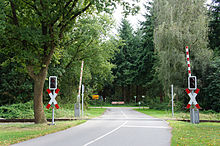
Entrance to Bürstel
|
||
Bürstel is a district of the municipality of Ganderkesee in the Lower Saxony district of Oldenburg . This also includes the farms in Dehlthun and Thienfelde .
Geography and transport links
The district is located about 2.5 km southwest of Ganderkesee. There is a connection to Ganderkesee via bus line 244.
The Bürsteler Fuhrenkamp , an approximately 57 hectare forest area, was only created through reforestation in 1780. Today it is a recreational area, separated from the actual village by the Delmenhorst – Hesepe railway line .
history
Bürstel is mentioned for the first time in the late 13th century in the oldest feudal register of the Counts of Oldenburg-Bruchhausen. In 1647 the place had 13 farms. In 1682 a school was established, the building of which was rebuilt several times. Since it was closed in 1971, it has served the local and homeland association.
Attractions
The Bürstel home parlor has existed in the old school since January 30, 1995 and illustrates the life of the Ganderkese people in the past.
There is also a Melkhus and an alpaca breeding farm with 60 animals in the village . The Heidenwall is located near Dehlthun , a ring wall, probably from the 9th or 10th century.
literature
Local and local history association Bürstel-Immer eV: Village chronicle Bürstel-Immer, Delmenhorst 2002
Web links
Individual evidence
- ↑ Numbers, data, facts. Ganderkesee community, March 21, 2016, accessed April 26, 2017 .
- ^ NWZ-Online: piece by piece towards the museum; accessed December 10, 2017.
- ↑ Wittekind Alpacas; accessed December 10, 2017.


