Brickstone
| Brickstone | ||
|---|---|---|
|
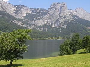
View of the Grundlsee with Backenstein (middle), Reichenstein (right) |
||
| height | 1772 m above sea level A. | |
| location | Grundlsee , Styria , Austria | |
| Mountains | Dead Mountains | |
| Dominance | 0.7 km → Häuslkogel | |
| Notch height | 70 m | |
| Coordinates | 47 ° 39 '18 " N , 13 ° 52' 4" E | |
|
|
||
| rock | Tressenstein lime | |
| Age of the rock | law | |
| Normal way | Hike from Grundlsee over the Almbergweg | |
The backenstein is 1772 m above sea level. A. high mountain in the dead mountains in Austria . The mountain, which towers around 1000 meters above the Grundlsee, with its striking, around 600-meter high rock face, is the local mountain of the Grundlsee community .
Ascent to the summit
From the Grundlsee town center ( 732 m ) via the marked Almbergweg (path no.235) towards Albert-Appel-Haus to the Backensteinsattel ( 1600 m ) and from there via the marked path no.236 to the summit at 1772 m . Walking time around three hours.
The summit cross of the mountain is located around 250 m south of the summit.
Literature and maps
- Wolfgang Heitzmann: Salzkammergut with the Totem Mountains and Dachstein: high-altitude trails, summit tours, via ferratas . Tour No. 48, pp. 190-192. New edition Bruckmann Verlag, Munich 2002, ISBN 3-7654-3336-5 .
- ÖK 50, sheet 97 (Bad Mitterndorf).
- Alpine Club Map Bl. 15/1 (Totes Gebirge - West), 1: 25,000; Austrian Alpine Club 2014; ISBN 978-3-928777-29-2 .
Web links
Commons : Backenstein - collection of pictures, videos and audio files

