Baganga
| Municipality of Baganga | ||
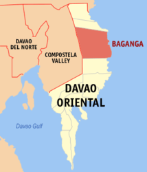
| Location of Baganga in the Davao Oriental province | ||
|---|---|---|

|
||
| Basic data | ||
| Region : | Davao | |
| Province : | Davao Oriental | |
| Barangays : | 18th | |
| PSGC : | 112501000 | |
| Income class : | 1st income bracket | |
| Households : | 8221 May 1, 2000 census
|
|
| Population : | 56,241 August 1, 2015 census
|
|
| Population density : | 56241 / 945.50 inhabitants per km² | |
| Area : | 945.50 km² | |
| Coordinates : | 7 ° 34 ' N , 126 ° 34' E | |
| Postal code : | 8204 | |
| Mayor : | REMEGIO G. NAZARENO | |
| Website: | http://www.baganga.gov.ph/ | |
| Geographical location in the Philippines | ||
|
|
||
Baganga is a metropolitan municipality in the Davao Oriental Province and is located on the east coast of Mindanao Island in the Philippines . It has 56,241 inhabitants (August 1st 2015 census) who live in 18 barangays .
geography
The community of Baganga is approximately 294 km from Davao City International Airport and can be reached via Mati City along the coastal road. The community occupies an area of 945.50 km² along the east coast of Mindanao Island. The Baganga Bay Protected Landscape and Seascape nature reserve is located within the municipal area .
Barangays
The metropolitan area is divided into 18 barangays .
|
|
Sons and daughters
- Nolly Buco (* 1963), Roman Catholic clergyman, auxiliary bishop in Antipolo
