Cateel
| Municipality of Cateel | ||
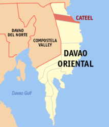
| Location of Cateel in the Davao Oriental Province | ||
|---|---|---|

|
||
| Basic data | ||
| Region : | Davao | |
| Province : | Davao Oriental | |
| Barangays : | 16 | |
| PSGC : | 112505000 | |
| Income class : | 2nd income bracket | |
| Households : | 6091 May 1, 2000 census
|
|
| Population : | 40,704 August 1, 2015 census
|
|
| Population density : | 74.6 inhabitants per km² | |
| Area : | 545.56 km² | |
| Coordinates : | 7 ° 47 ' N , 126 ° 27' E | |
| Postal code : | 8205 | |
| Mayor : | Camilo T. Nuñez | |
| Website: | http://www.cateel.gov.ph/ http://www.cateel.gov.ph/ | |
| Geographical location in the Philippines | ||
|
|
||
Cateel is a metropolitan municipality in the Davao Oriental Province and is located on the island of Mindanao in the Philippines . It has 40,704 inhabitants (August 1, 2015 census) who live in 16 barangays . It belongs to the second income bracket of the communities in the Philippines and is considered to be partially urbanized .
It is located on the east coast of Mindanao Island north of Mati City and can be reached from there via the coastal road. The municipality covers an area of 545.56 km² and the terrain is mountainous except for the coastal strip. Parts of the Aliwagwag Protected Landscape are located in the municipal area .
Barangays
The metropolitan area is divided into 16 barangays.
|
|
