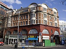
Elephant & Castle station
Elephant & Castle is the name of a transport hub in the London borough of Southwark . It is named after a pub that was located at the intersection of five main streets. The hub consists of a railway station, a London Underground station complex and bus stops. It is located on the border of the Travelcard tariff zones 1 and 2.
investment
railroad
The four-track station is located on a viaduct and has entrances on Elephant Road and on the upper floor of the Elephant and Castle shopping center. The platforms can only be reached via stairs, not elevators or escalators . Switching to and from the underground is permitted by tariff, although the shopping center must be crossed or bypassed in the public street.
Two bundles of suburban lines hold: the Southeastern line between Blackfriars and Sevenoaks , as well as the Thameslink lines of the operating company Govia Thameslink Railway , which is also responsible for station management.
During rush hour, trains go to the following stations:
- 2 an hour to London Blackfriars
- 2 an hour to Kentish Town
- 4 per hour to St Albans City
- 2 per hour according to Sevenoaks
- 2 per hour according to Orpington
- 4 per hour to Sutton , of which 2 drive the circular railway there clockwise via Mitcham Junction and 2 counterclockwise via Wimbledon .
- 1 to 2 additional trains to Ashford , Rochester , Orpington or Dover Priory
London underground
The underground station is served by the Northern Line and the Bakerloo Line , each of which has its own platform. There are two station buildings about 100 meters apart. The platforms are accessed by elevators and narrow spiral stairs.
history
The London, Chatham and Dover Railway opened the railroad station provisionally on October 6, 1862, then permanently in February 1863.
The Northern Line station was opened on December 18, 1890 by the City and South London Railway (C & SLR). At the time, it was part of the world's first electrically operated subway. The opening of the station of the Bakerloo Line took place on August 5, 1906 by the then Baker Street and Waterloo Railway (BS&WR). Although the stations had been built by two different companies, they were connected by a pedestrian tunnel on August 10, 1906.
In its construction, the C & SLR station resembled the Kennington station, which still exists today . It was partially rebuilt in the 1920s when the tunnel below was widened to increase capacity. In the 1960s, the old building had to give way to the shopping center, which has dominated the appearance of the square ever since. In December 2003 a new, modern station building was opened. The BS&WR station, on the other hand, with its glazed terracotta bricks looks almost like it did in the early years and is a typical example of the work of the architect Leslie Green .
The station buildings were named after the intersection of Elephant and Castle, where St. George's Road, London Road, Newington Causeway and New Kent Road meet. It was named after a pub that has been there since 1756, rebuilt and expanded several times over the centuries, damaged by the bombing of London by the German Air Force and demolished in 1959 in the course of being cleared after the Second World War. Since 1966 there has been a modern pub on the ground floor of an office building at the intersection, the name of which is intended to recall the historical model.
As part of a planned extension of the Bakerloo Line to Lewisham , the existing terminus would be abandoned and replaced by a new through station.
Web links
- Photo of the station building of the C & SLR (1914)
- Photo of the Bakerloo Line station building (1925)
Individual evidence
- ^ Northern Line. Clive's Underground Line Guides, accessed January 26, 2013 .
- ^ Bakerloo Line. Clive's Underground Line Guides, accessed January 26, 2013 .
- ^ Edward Sullivan: Evening Standard London Pub Bar Guide . Chapter “The Elephant And Castle” (page 71). Simon & Schuster, 1999. ISBN 9780684868400 .
- ^ A b Johnny Homer: Southwark Pubs . Chapter 21 "Elephant and Castle, No. 116 Newington Causeway, SE1 ". Amberley Publishing, 2017. ISBN 9781445668185 .
- ^ Bakerloo line extension. Transport for London, archived from the original ; accessed on October 20, 2019 .
| Previous station | Transport for London | Next station | ||
|---|---|---|---|---|
| Lambeth North | Bakerloo Line | final destination | ||
| Borough |
Northern Line (City Branch) |
Kennington | ||
| Previous station | National Rail | Next train station | ||
| Blackfriars | Thameslink | Denmark Hill | ||
| Loughborough Junction | ||||
|
Southeastern (Bedford − Gillingham) |
Herne Hill | |||
|
Southeastern (Kentish Town − Sevenoaks) |
Denmark Hill | |||
|
Southeastern (Bedford − Ashford) |
Bromley South | |||
Coordinates: 51 ° 29 ′ 40.6 " N , 0 ° 5 ′ 58.4" W.


