
Baiti
| Location of Baitis | |
|---|---|
  |
|
| surface | |
| Rank (within Naurus) | 7 (of 14) |
| All in all | 1.2 km² |
| Residents | |
| Rank (within Naurus) | 9 (of 14) |
| Total status (2011) | 513 |
| density | 428 inhabitants / km² |
| geography | |
| Time zone | UTC +12 |
| Geographical location | 0 ° 31 ′ 0 ″ S , 166 ° 56 ′ 0 ″ E |
| width | approx. 0.5 km |
| length | approx. 2.0 km |
| Highest position | approx. 45 m |
| Average location | approx. 25 m |
| Lowest position | approx. 0 m |

|
|
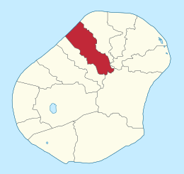
Baiti (locally also Baitsi [ bɛˈitʃi ]) is a district of the island state of Nauru , in the northwest of the island. It is bordered by Uaboe in the southwest, Ewa in the northeast, Anabar in the east and Anibare in the southeast. It is 1.2 km² and has 513 inhabitants. Baiti is part of the Ubenide constituency .
Baiti takes its name from the village of the same name, Baiti ; however, it is not known what the meaning of the word is.
Historic villages
Until 1968, today's Baiti district was a district , which consisted of 15 historic villages.
- Adrurior
- Aeonun
- Anakawida
- Anut
- Ataneu
- Atirabu
- Baiti
- Deradae
- Ibedwe
- Imangengen
- Imaraga
- Mangadab
- Mereren
- Umaruru
- Yatabang
Individual evidence
- ↑ Table 1: Population size and growth rate by district. ( Memento from September 24, 2015 in the Internet Archive ) In: Republic of Nauru. Census 2011. National Report on Population and Housing. Secretariat of the Pacific Community, p. 8. Retrieved July 15, 2015.