Aiwo
| Location Aiwos | |
|---|---|
| surface | |
| Rank (within Naurus) | 9 (of 14) |
| All in all | 1.1 km² |
| Residents | |
| Rank (within Naurus) | 3 (of 14) |
| Total status (2011) | 1,220 |
| density | 1,109 inhabitants / km² |
| geography | |
| Time zone | UTC +12 |
| Geographical location | 0 ° 32 '12 " S , 166 ° 54' 38" O |
| width | approx. 0.9 km |
| length | approx. 1.3 km |
| Highest position | approx. 65 m |
| Average location | approx. 26 m |
| Lowest position | approx. 0 m |
| politics | |
| MPs |
Milton Dube Aaron Cook |

|
|
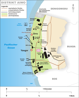
Aiwo (formerly Aiue , also Yangor ) is a district of the island state of Nauru , in the southwest of the island. It borders Denigomodu to the north, Buada to the east, and Boe to the south. It is 1.1 km² and has 1220 residents. Aiwo is sometimes referred to as the unofficial capital of Naurus, although that would actually apply more to Yaren as the seat of government and parliament. Nauru has no official capital.
Aiwo takes its name from the historical village of the same name Aiwo; according to Paul Hambruch it means "peaceful".
Aiwo is home to the country's main industry and commercial center. Here you can find:
- the Aiue Boulevard
- the Aiwo Harbor
- the island's Chinatown
- a youth hostel, the OD-N-Aiwo Hotel (the other hotel, Menen Hotel , is in Meneng )
- The power plant
- the Linkbelt oval
- the Nauru College
- the processing services and loading cranes of the NPC
- the main church of the Nauruan Protestants (Orro Congregational Church)
- the only post office on the island
- the Civic Center as a building for conferences, forums, etc.
Historic villages
Until 1968, today's Aiwo district was a Gau , which consisted of eight historic villages.
- Aiwo
- Aribweabwe
- Eaterienago
- Eatoborowada
- Gabab
- Orro
- Sigamei
- Tebata
Personalities
- René Harris (1947–2008), politician and four-time President Naurus
- Marlene Moses (* 1961), politician and diplomat
- Yukio Peter (* 1984), weightlifter
Web links
Commons : Aiwo - collection of images, videos and audio files
Individual evidence
- ↑ Table 1: Population size and growth rate by district. ( Memento from September 24, 2015 in the Internet Archive ) In: Republic of Nauru. Census 2011. National Report on Population and Housing. Secretariat of the Pacific Community, p. 8. Retrieved July 15, 2015.


