Balaka
| Balaka | ||
|---|---|---|
|
|
||
| Coordinates | 14 ° 59 ′ S , 34 ° 58 ′ E | |

|
||
| Basic data | ||
| Country | Malawi | |
| Southern region | ||
| District | Balaka | |
| ISO 3166-2 | MW-BA | |
| height | 600 m | |
| surface | - | |
| Metropolitan area | 2193 km² | |
| Residents | 36,308 (2018) | |
| Metropolitan area | 253.098 | |
| density | - | |
| Metropolitan area | 115.4 Ew. / km² | |
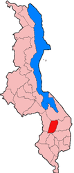
Balaka is a city in southern Malawi . It is 600 meters above sea level and is a rapidly growing economic center with 36,308 inhabitants (as of 2018). Balaka is the capital of the district of the same name , which has an area of 2193 km² and 253,098 inhabitants. Balaka is conveniently located on the paved roads Blantyre - Zomba - Dedza - Lilongwe and Zomba Chipoka - Salima as well as on the railway line Blantyre-Chipoka-Lilongwe. The Nkaya branch to the Mozambican port of Nacala is 12 kilometers south . The trains for this are put together at the marshalling and freight yard near Balaka, and some are also loaded and unloaded.
The Balaka District consists of 82 villages that make up five metropolitan areas. One of them is the city of Balaka. It is characterized by traditional houses.
Balaka has a 1,000 m long runway, elementary and secondary schools and a hospital, most of which were built after 2000.
Individual evidence
- ↑ City Population: Population figures of the cities in Malawi 1977 to 2018 (English), accessed on September 22, 2019
