Banbridge
|
Banbridge Irish Droichead na Banna |
||
|---|---|---|
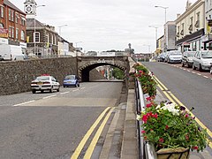
| 'The Cut' in Banbridge | ||
| Coordinates | 54 ° 21 ′ N , 6 ° 16 ′ W | |
|
|
||
| Residents | 14,744 | |
| administration | ||
| Post town | BANBRIDGE | |
| ZIP code section | BT32 | |
| prefix | 028 | |
| Part of the country | Northern Ireland | |
| District | Banbridge | |
Banbridge ( Irish Droichead na Banna , dt. "Bannbrücke") is a Northern Irish town in the historic County Down on the river Bann and was the administrative seat of the former District Banbridge , which in 2015 in the District Armagh, Banbridge and Craigavon . Banbridge is located between Belfast and Dublin, 20 kilometers south of Belfast on the A1.
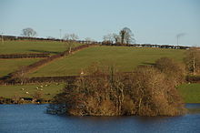
Which is located in the area Brontë Homeland center dasa cemetery Cloughskelt and crannóg of Loughbrickland .
sons and daughters of the town
- Francis Crozier (1796-1848), polar explorer
- Tommy Evans (* 1973), racing cyclist
- Dermott Lennon (* 1969), former world champion in show jumping
- John McAreavey (born 1949), Roman Catholic Bishop of Dromore
- Joseph M. Scriven (1819–1886), poet of the hymn What a Friend We Have in Jesus ( What a friend is our Jesus )
- James Shields (1762–1831), American politician
- Jonathan Tuffey (* 1987), soccer goalkeeper
Web links
Commons : Banbridge - collection of images, videos and audio files
Individual evidence
- ↑ Northern Ireland Census 2001 Key Statistics for Settlements: Key Statistics Tables ( Memento of the original from February 17, 2010 in the Internet Archive ) Info: The archive link was inserted automatically and has not yet been checked. Please check the original and archive link according to the instructions and then remove this notice. , Northern Ireland Statistics


