Bangar
| Municipality of Bangar | ||
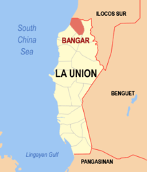
| Location of Bangar in La Union Province | ||
|---|---|---|

|
||
| Basic data | ||
| Region : | Ilocos region | |
| Province : | La Union | |
| Barangays : | 33 | |
| District: | 1. District of La Union | |
| PSGC : | 013306000 | |
| Income class : | 3rd income bracket | |
| Households : | 5699 May 1, 2000 census
|
|
| Population : | 35,947 August 1, 2015 census
|
|
| Population density : | 963.9 inhabitants per km² | |
| Area : | 37.2917 km² | |
| Coordinates : | 16 ° 54 ′ N , 120 ° 25 ′ E | |
| Postal code : | 2519 | |
| Mayor : | Gary N. Pinzon | |
| Website: | www.bangar.gov.ph | |
| Geographical location in the Philippines | ||
|
|
||
Bangar is a municipality in the Philippine province of La Union and is located on the South China Sea . In the north it borders on the province of Ilocos Sur . The terrain is very flat in the west and hilly in the east. The Amburayan River , which reaches a 5.5 km wide delta at its mouth, forms the northern limit of the municipality. The population of Bangar lives mainly from agriculture.
Bangar is divided into the following 33 barangays :
|
|
|
