Bangar (Brunei)
| Mukim Bangar Bangar |
||
|---|---|---|
|
|
||
| Coordinates | 4 ° 42 ′ N , 115 ° 4 ′ E | |
| Basic data | ||
| Country | Brunei | |
| Temburong | ||
| ISO 3166-2 | BN-TE | |
| surface | 113 km² | |
| Residents | 2696 (2016) | |
| density | 23.9 Ew. / km² | |
|
The Mukim of Temburong
|
||
Bangar is a Mukim in the Temburong District of Brunei . The Mukim (sub-district) covers 113 km². In 2016 it had around 2,700 inhabitants.
geography
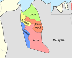
Bangar is located in the northwest of the Temburong district and borders the Mukim Labu in the north, Mukim Batu Apoi in the east, Mukim Amo in the southeast, Mukim Bokok in the southwest and Limbang, Sarawak ( Malaysia ) in the west and north. The island of Pulau Kibi on the coast belongs to the Mukim . Bangar is located in the Limbang Syncline area , which extends west from the Sarawak area into the Brunei area. The first steep cliffs of the Syncline form part of the border with Sarawak in the west and also determine the road layout on the border, as well as the southern border with Amo.
Further south the border runs along the strongly meandering Sungai Tabahan . Other rivers are Sungai Kibi and Sungai Subok .
Bangar center
The actual place is on the south-east border of the sub-district, it hugs the slopes of the Limbang Syncline and lies at the breakthrough of the Sungai Kibi. The Peradayan Forest Reserve (Amo) connects directly to the southeast . In the center there is a bank, the mosque Masjid Utama Mohammad Salleh and the hospital Pengiran Isteri Hajjah Mariam Hospital .
administration
The sub-district is one of the five Mukim of Temburong District. He reports to a Penghulu , the incumbent is currently Abdul Rahman bin Merusin .
Administrative division
The Kampong belong to the Mukim
- Pekan Bangar Lama
- Pekan Bangar Baru
- Perkemahan Bangar
- Kampong Menengah
- Kampong Sungai Sulok
- Kampong Sungai Tanit
- Kampong Sungai Tanam
- Kampong Balayang
- Kampong Semamang
- Kampong Buang Bulan
- Kampong Belingus
- Kampong Batang Tuau
- Kampong Seri Tanjong Belayang
- Kampong Puni
- Kampong Ujong Jalan
Border post
A border post to Malaysia's Sarawak is located in Kampung Puni, 5 km from the center of Bangar. There used to be a ferry service over the Pandaruan River , which in parts forms the border, but the Malaysia-Brunei Friendship Bridge was opened in 2013 and has been open to traffic since December 8, 2013. Previously, the customs stations were 500 m from the ferry terminal at Bangar, while the Malaysian customs were located at Limbang Wharf in Limbang , 15 km away. Another checkpoint was later opened at Pandaruan.
Individual evidence
- ↑ a b Jabatan Daerah Temburong, Kementerian Hal Ehwal Dalam Negeri - MUKIM BANGAR ( ms )
- ↑ Data Set Population Temburong Population by Mukims (XLSX)
- ↑ Ahmed Numair, Mohamed AK El-Ghali, Abdul Hadi Bin Abd Rahman, Joel Ben-Awuah: Depositional Depositional Environment of Shallow-Marine Sandstones from Outcrop Gamma-Ray Logs, Belait Formation, Meragang Beach, Brunei Darussalam. 2013 In: researchgate.net (PDF).
- ↑ GeoNames Sungai Tabahan .
- ^ GeoNames Sungai Kibi
- ↑ GeoNames Sungai Subok .
- ↑ Jabatan Daerah Temburong, Kementerian Hal Ehwal Dalam Negeri - Profile Mukim ( ms )
Web links
- pelitabrunei.gov.bn
- information.gov.bn Temburong District


